Satellite Remote Sensing for Urban Governance: Construction Progress & Illegal Waste Dumping Monitoring
Powered by YaoHai KeChuang Satellite | Xinhe Aerial Remote Sensing Information Technology (Anhui) Co., Ltd.
Abstract
Against the backdrop of urban renewal and refined city management, traditional manual patrols face long-standing pain points: limited inspection frequency, widespread blind spots, and untraceable on-site processes, which lead to information asymmetry, delayed supervision and frequent disputes over construction progress and land use. High-resolution satellite remote sensing technology provides an objective, traceable "space ruler" for urban governance. By conducting time-series dynamic monitoring of construction sites, vacant land parcels and illegal waste dumping, every surface change becomes verifiable and auditable.
This article presents a practical case of high-resolution satellite monitoring for an urban vacant land parcel, covering the full construction cycle from site preparation to project completion. It introduces the standardized workflow, phase-by-phase monitoring results and core application value of satellite remote sensing in urban construction supervision and land compliance management. With self-operated 0.5m high-resolution YaoHai KeChuang Satellite, Xinhe Remote Sensing provides global clients with compliant, accurate and traceable space-based urban governance solutions.
1. Introduction: Pain Points of Traditional Urban Site Management
For urban administrators, construction owners and regulatory authorities, three core issues have long been difficult to solve:
·How to accurately verify the actual progress of engineering projects?
·How to detect illegal occupation of idle and reserved land parcels in time?
·How to identify and trace illegal dumping of solid waste in remote areas?
Rooted in limited manual inspection frequency, coverage gaps and lack of persistent process records, these problems result in passive supervision, cost disputes and compliance risks. Today, high-resolution satellite remote sensing, with its all-area coverage, periodic revisit capability and objective imaging features, has become a core technical means to empower refined urban governance.
2. Project Overview: Space-Based Monitoring for a Vacant Urban Parcel
Recently, Xinhe Remote Sensing was entrusted by a municipal administrative department to carry out high-resolution time-series remote sensing monitoring on a vacant land parcel within its jurisdiction, focusing on construction progress and illegal solid waste dumping.
We acquired 15 phases of high-resolution optical satellite imagery to fully record the temporal changes of the parcel and accurately restore the surface status. The project not only provided objective and accurate data evidence for project progress verification, but also built a traceable and verifiable space-based information archive for government supervision, and was highly recognized by the client.
Basic Project Information
·Monitoring object: A vacant urban land parcel, covering the full construction cycle from preparation to main project completion
·Monitoring period: April 3, 2025 – February 13, 2026
·Imaging configuration: 15 phases of high-resolution optical satellite imagery, enabling accurate identification of surface changes
·Implementation standard: Strictly in accordance with relevant national specifications and standardized full-process operation
·Core objective: To identify dynamic changes in land use, construction activities and site transformation, record full-cycle evolution characteristics, and provide authoritative basis for urban management and land control.
3. Phase-by-Phase Monitoring Results
3.1 Phase 1: Initial Site Status (April 2025)
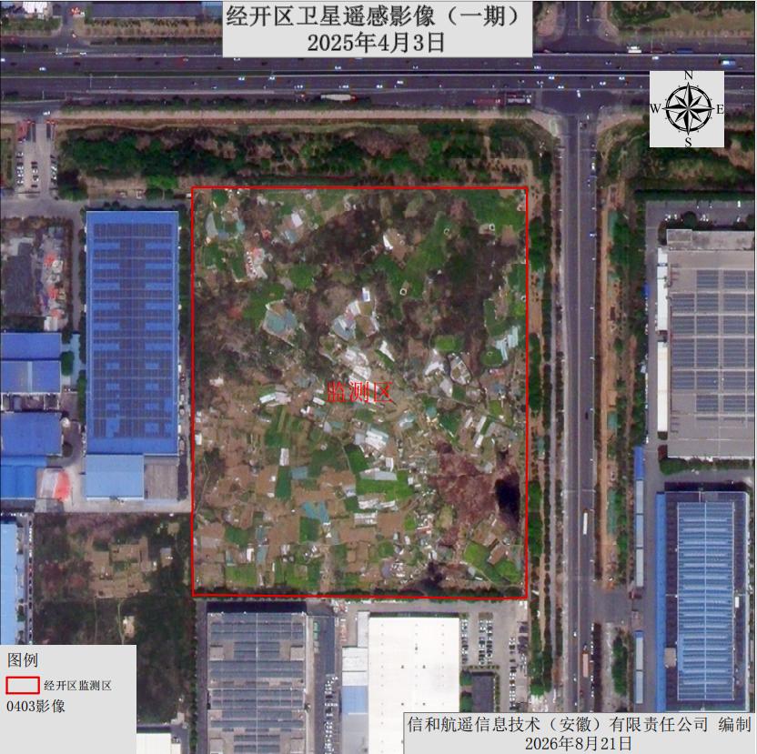
In this phase, the parcel maintained its original landform as a whole. The ground was dominated by dry land, with no large-scale construction traces, and only scattered temporary simple structures existed.
3.2 Phase 2: Project Launch (April – May 2025)
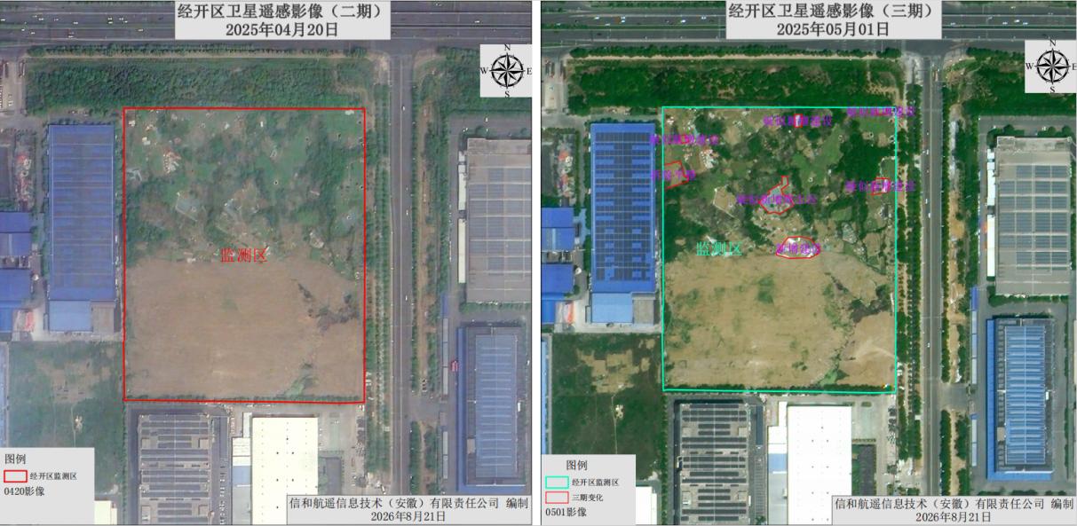
Obvious earthmoving traces first appeared on the south side of the parcel, with surface soil disturbed, marking the official start of construction operations. Sporadic demolition operations also occurred simultaneously in the northern part of the site.
3.3 Phase 3: Site Grading & Earthworks (June – July 2025)
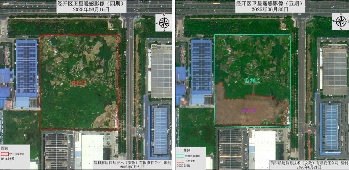
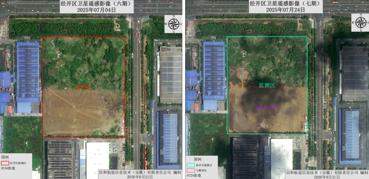
After the first site clearance, weeds regrew on the surface, and a second round of site grading was carried out. Unauthorized soil mounding first appeared in the northwest of the parcel.
3.4 Phase 4: Early Construction Stage (August 2025)
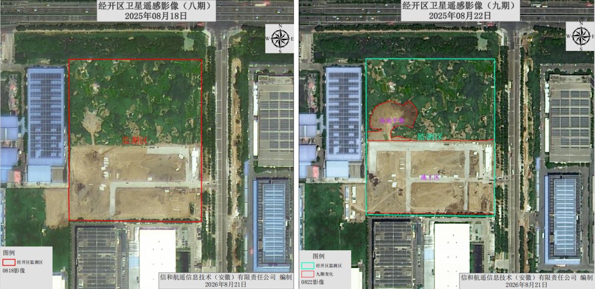
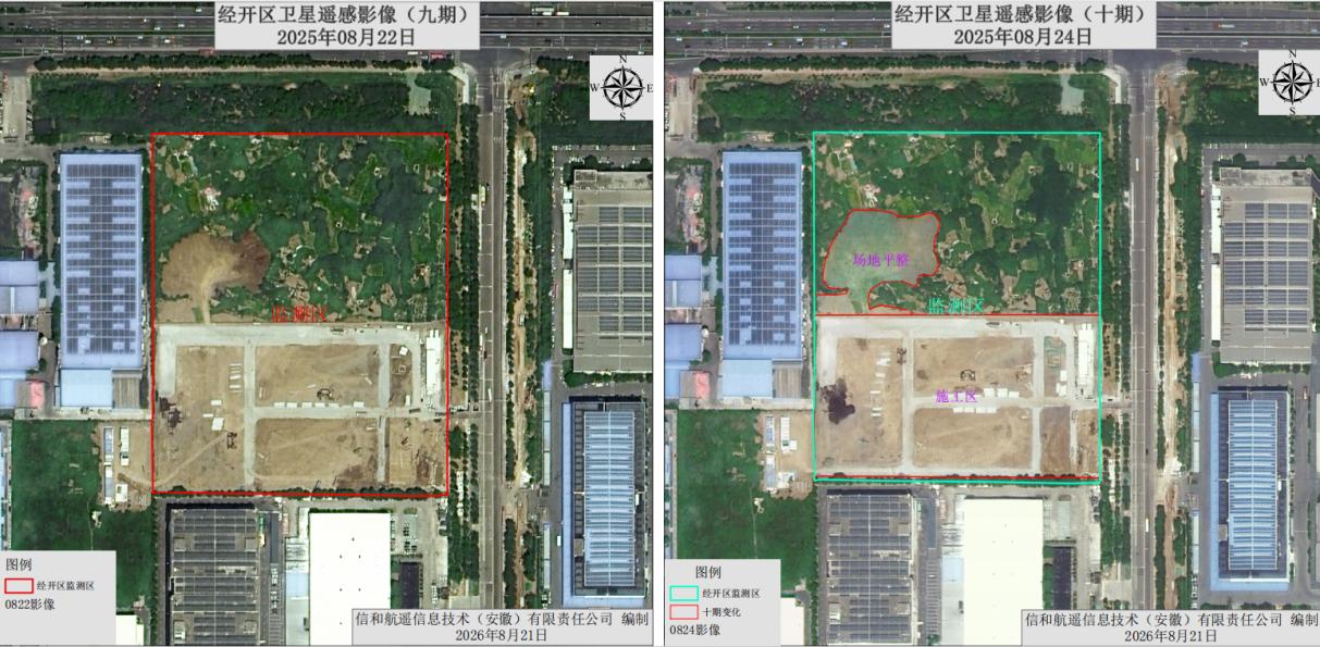
The construction pace accelerated significantly. New hardened construction access roads were added in the south of the parcel; multiple temporary construction buildings were built within the area; the illegal soil mounding on the northwest side continued to expand, and was later covered with dust control nets.
3.5 Phase 5: Main Construction Stage (October – December 2025)
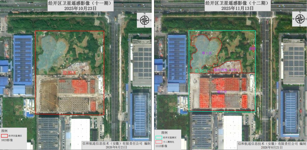
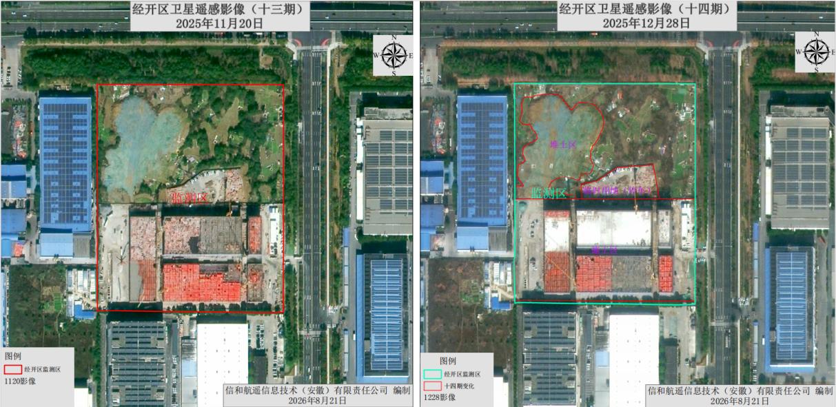
The parcel entered the main construction stage in full swing. Pile foundations, tower cranes and building frame structures could be clearly identified in satellite imagery. An enclosed area with walls was formed in the north of the site as temporary construction land, and supporting construction functional areas were basically completed. The illegal soil mounding on the northwest side further expanded.
3.6 Phase 6: Construction Completion Phase (February 2026)
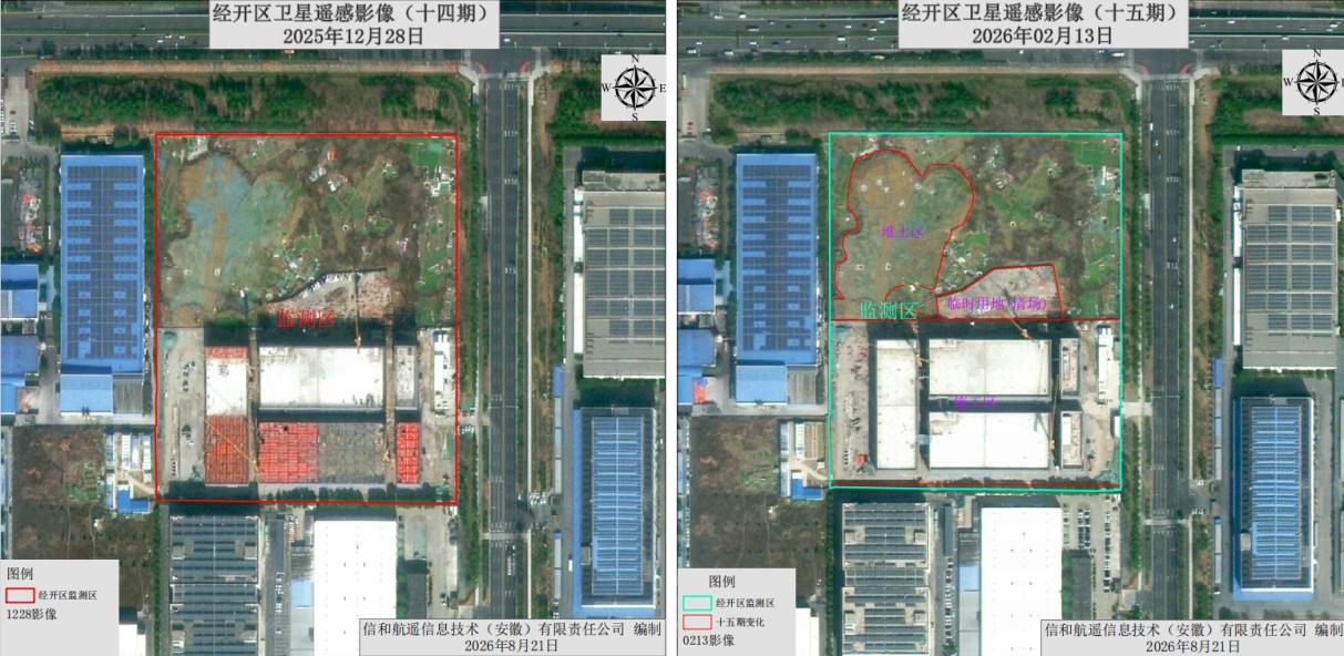
As of February 2026, the main building construction of the parcel was basically completed, with tower cranes remaining in place. Temporary construction land had been largely cleared and restored, and the overall project entered the final completion stage.
Through multi-phase image comparison, the construction progress on the south side and the illegal soil mounding on the north side of the parcel were fully documented, which can be used as the basis for the follow-up work of the urban management department.
4. Quality Control: Four-Step Workflow for Accurate & Objective Results
To ensure the comparability of multi-phase imagery and the accuracy of change extraction, the project strictly follows a standardized workflow, with layer-by-layer quality control from data source to result output:
1. Homologous High-Resolution Image Screening
Strictly select high-resolution imagery of the same resolution level and the same coordinate datum to ensure no systematic deviation in before-and-after comparison.
2. Unified Preprocessing & Calibration
Complete radiometric correction, geometric correction and other procedures to eliminate imaging distortion and radiation differences, achieve precise spatial alignment of multi-phase imagery, and ensure pixel-level accuracy of change extraction.
3. AI-Assisted + Manual Refined Interpretation
Adopt deep learning models to initially extract change patches, and then conduct manual verification by experienced interpreters to eliminate misjudgments and supplement omissions, ensuring true and reliable results.
4. Standardized Result Archiving
Compile standardized metadata files synchronously, fully recording imagery time phase, spatial reference, sensor information and other details. All result data are traceable, verifiable and reusable for long-term management.
5. Application Value of Satellite Remote Sensing in Urban Governance
5.1 Engineering Construction Management
In the field of engineering construction, satellite remote sensing can fully record the whole process of "before, during and after" construction through time-series comparison of high-resolution imagery. It provides third-party objective evidence for progress verification, progress payment, project settlement and audit supervision, effectively avoiding schedule disputes and compliance risks.
5.2 Urban Land & Compliance Supervision
In urban governance, reserved land, expropriated unbuilt parcels and temporary idle spaces are valuable resources, but also high-incidence areas of illegal construction, waste dumping and unauthorized occupation.
Traditional manual patrols are inefficient and hard to achieve full coverage with high frequency. Satellite remote sensing, with periodic revisit (monthly, bi-monthly, etc.), can implement "scanning-style" supervision over the entire area of parcels. It can quickly detect abnormal change patches such as new structures, soil mounding and vegetation damage, form a suspected problem list, and then cooperate with ground verification to form a closed loop of "space observation + ground inspection".
This mode not only greatly reduces the labor cost of inspection, but also shifts land management from passive response to proactive discovery. It establishes a dynamic "health file" for every idle land parcel, ensures that the planned use is consistent with the actual state, and realizes a smart supervision closed loop of "early detection, rapid disposal and full traceability".
6. Integrated Space-UAV-Ground Solution
Our company also provides an integrated space-ground-UAV linkage inspection technical service, building a full-chain closed loop of satellite macroscopic screening – UAV low-altitude verification – 3D visualized management.
·Satellite remote sensing first locates suspected change patches over a large area;
·UAVs conduct close-range accurate evidence collection to quickly confirm the location, scope and type of stockpiles and dumps, significantly improving inspection accuracy;
·Digital platform replaces traditional paper ledgers, completely avoiding the risk of data loss and realizing full-process traceable smart supervision.
Final Thoughts
From construction progress supervision to dynamic inspection of vacant parcels, from accurate identification of solid waste dumping to early warning of illegal construction, satellite remote sensing technology is deeply integrating into all aspects of urban governance. It breaks the time and space limitations of traditional manual patrols, and provides a solid basis for management decisions with objective, accurate and traceable image data.
Multi-phase satellite imagery constitutes not only "comparison maps", but also a set of spatiotemporal archives with legal and audit value. Whether it is illegal waste dumping, project progress verification, engineering quantity calculation, compliance supervision or problem rectification review, satellite monitoring enables all parties to reach consensus based on the same set of data, truly realizing more efficient management, more transparent supervision and more reliable traceability.
With self-operated YaoHai KeChuang 0.5m high-resolution satellite and full-stack remote sensing delivery capabilities, Xinhe Remote Sensing is committed to providing global clients with stable, compliant and cost-effective urban governance remote sensing solutions. If you have needs for construction site monitoring, land compliance management or customized urban remote sensing projects, welcome to contact our team for a free technical consultation and customized quotation.