Remote Sensing for Demolition Progress Monitoring: A Case Study of Industrial Park Factory Demolition
Powered by YaoHai KeChuang Satellite | Xinhe Aerial Remote Sensing Information Technology (Anhui) Co., Ltd.
Abstract
In scenarios such as urban village demolition, industrial park upgrading, factory removal, high-standard farmland supervision and bank post-loan monitoring, the authenticity of construction progress and the fairness of engineering quantity calculation have always been core challenges for project settlement and compliance supervision. Traditional on-site manual verification is limited by low inspection frequency, untraceable process records and lack of cross-cycle reference, which often leads to information asymmetry and frequent disputes.
Recently, entrusted by an industrial park operator, Xinhe Remote Sensing carried out high-resolution dynamic satellite monitoring on the demolition of Workshop #1 in the park. Using three phases of 0.75m ultra-high-resolution satellite imagery, we fully captured the temporal changes before, during and after demolition, and accurately quantified the demolition progress and site status. This solution not only provides objective and accurate data evidence for progress verification and project settlement, but also builds a traceable and verifiable space-based information archive for regulatory authorities, empowering engineering compliance and fairness with technology.
1. Project Overview: Space-Based "Ruler" for Demolition Progress
This monitoring project was carried out for Workshop #1 and its surrounding areas in an industrial park, with the core objectives of objective recording, quantitative comparison and full-process traceability. The whole project strictly follows relevant national standards and specifications.
Core Monitoring Parameters
·Monitoring target: Workshop #1 of an industrial park
·Monitoring period: November 16, 2025 – December 5, 2025
·Imaging resolution: All three phases of imagery have a spatial resolution of 0.75m, uniformly adopting the WGS84 datum, with clear and identifiable ground feature outlines
·Core value: Quantitatively record the progress of demolition construction, and provide authoritative third-party data basis for progress verification, project settlement and compliance supervision.
2. Satellite Observation Record: Key Phases of Factory Demolition
Through registration and comparison of three phases of high-precision imagery, the phased changes of factory demolition are clearly visible, and the construction pace and site status are straightforward at a glance.
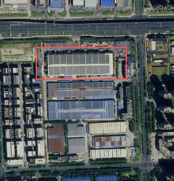
2.1 Phase 1: Baseline Period (November 16, 2025)
Key feature: Original state
The imagery of this phase serves as the baseline map for progress monitoring, clearly presenting the original state of the factory building. With stable ground features and clear spatial reference, it provides a reliable baseline for accurate calculation of subsequent demolition changes.
2.2 Phase 2: Demolition Period (November 26, 2025)
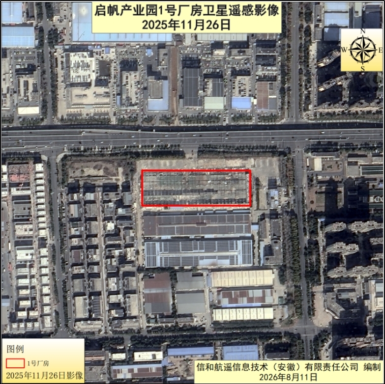
Key feature: Partial roof demolition, main structure remaining
As the mid-term image of progress monitoring, this phase clearly shows the mid-demolition status: the north, south and middle parts of the factory roof have been demolished, but the overall outline of the main building remains intact. The stable ground features and clear spatial reference provide a reliable basis for accurate calculation of subsequent demolition changes.
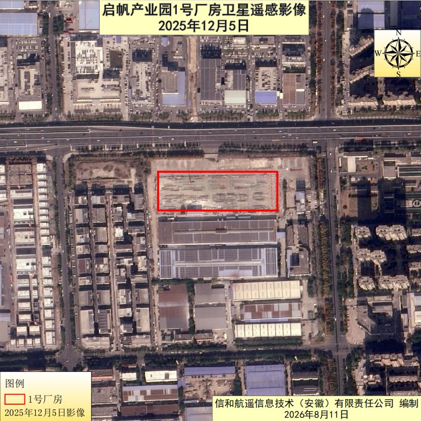
2.3 Phase 3: Completion Period (December 5, 2025)
Key feature: Main structure fully demolished, site grading in final stage
Nine days later, the third phase of imagery shows significant progress in demolition construction:
·The main structure of the factory has been completely demolished, with only a small number of scattered components remaining;
·The original building position is largely exposed, and construction waste generated by demolition is piled up in zones;
·The overall flatness of the site has been significantly improved, and the overall demolition work has entered the final stage.
The comparison shows that the demolition volume is large and the progress change is intuitive and quantifiable.
3. Quality Control: Four-Step Workflow for Objective & Accurate Results
To ensure the comparability of multi-phase imagery and the accuracy of change extraction, the project team implements full-process standardized operations, with layer-by-layer quality control from data source to result output.
1. Homologous High-Resolution Image Screening
Strictly select high-resolution imagery of the same accuracy level and consistent coordinate datum. All data are 0.75m resolution with WGS84 coordinate system, ensuring no systematic deviation in before-and-after comparison.
2. Unified Preprocessing & Calibration
Complete preprocessing procedures such as radiometric correction and geometric correction to eliminate imaging geometric distortion and radiation differences, achieve precise spatial alignment of multi-phase imagery, and guarantee the accuracy of change extraction.
3. Manual Refined Interpretation
Adopt professional manual visual interpretation scheme to accurately extract change patches such as demolition scope, demolition progress and site grading status, ensuring no omission or misjudgment and guaranteeing true and reliable results.
4.Standardized Result Archiving
Compile standardized XML metadata files synchronously, fully recording core information such as imagery time phase, spatial reference and sensor. The result data are traceable, reusable and verifiable.
4. Monitoring Conclusions: Verifiable Progress, Controllable Compliance, Traceable Data
Based on systematic comparative analysis of three phases of imagery, this monitoring forms four core conclusions, covering multiple dimensions of progress, quality and compliance:
1.Authentic and reliable data results Multi-phase imagery has high registration accuracy and reliable ground feature interpretation, with complete and standardized orthorectified imagery and metadata information, which can intuitively and objectively quantify the actual progress of demolition construction.
2.Traceable demolition progress Through image comparison, key time nodes of the factory from "partial roof demolition" to "full main structure demolition" can be accurately identified, and phased construction traces are fully retained, providing solid technical support for the client.
3.Compliant and orderly on-site construction During the monitoring period, no illegal reconstruction on the original site, out-of-range construction or unauthorized temporary construction was found, and the construction scope and operation behaviors are generally compliant.
4.Long-term reusable value of results The imagery and reports formed by this monitoring can be used as supporting materials for project settlement, audit verification and regulatory filing. The technical system can also be applied to the demolition, reconstruction and construction monitoring of other parcels in the park for normalized supervision.
5. Our Capabilities
As a national high-tech enterprise and a key enterprise in Hefei's space information industry chain, we independently operate YaoHai KeChuang — Anhui's first commercial optical remote sensing satellite, and integrate resources from more than 200 cooperative satellites to build a "self-operated + collaborative" satellite constellation system, truly realizing reliable data access with "space eyes" at hand.
From data acquisition, intelligent interpretation to in-depth application, we have built a full-chain closed-loop service capability. Focusing on core scenarios such as land acquisition and demolition, engineering construction, high-standard farmland, bank post-loan supervision, agricultural insurance and legal evidence collection, we provide one-stop solutions including long-term dynamic monitoring, accurate quantitative demolition/construction scope, and full-process image archiving and verification.
Whether it is project progress control, accurate engineering quantity calculation, compliance supervision or archive retention, we restore real changes from a satellite perspective and support decisions with data, making management more efficient, supervision more transparent and traceability more reliable.
Xinhe Remote Sensing — making every change traceable, and every acre of land well-managed.
Xinhe Aerial Remote Sensing Information Technology (Anhui) Co., Ltd. | Global Commercial Remote Sensing Service Provider