Scope of business
Satellite Remote Sensing Comprehensive Service: Global Vision, Accurate Perception
Core keywords: high-resolution images, long-time-series monitoring, full-process processing
Xinhe Hangyao, relying on leading aerospace information technology, is committed to providing users with high-frequency, high-resolution, and long-time-series satellite remote sensing comprehensive solutions. The company has deeply integrated domestic high-quality remote sensing satellite resources and successfully launched Anhui Province's first commercial optical remote sensing satellite, establishing a leading position in the regional remote sensing data supply field.
We not only provide high-precision original images but also have strong backend data processing and production capabilities, covering stereo image pair processing, orthophoto map (DOM) production, and digital elevation model (DEM) construction. Relying on independently developed interpretation algorithms, we deeply explore the value of data, providing long-time-series and multi-dimensional analysis support for natural resource supervision, ecological and environmental protection monitoring, agricultural yield estimation, and dynamic water conservancy inspections. From the overall control of macro situations to the accurate characterization of micro changes, Xinhe Hangyao watches over the earth with "star eyes", making spatial big data a key support for scientific decision-making.

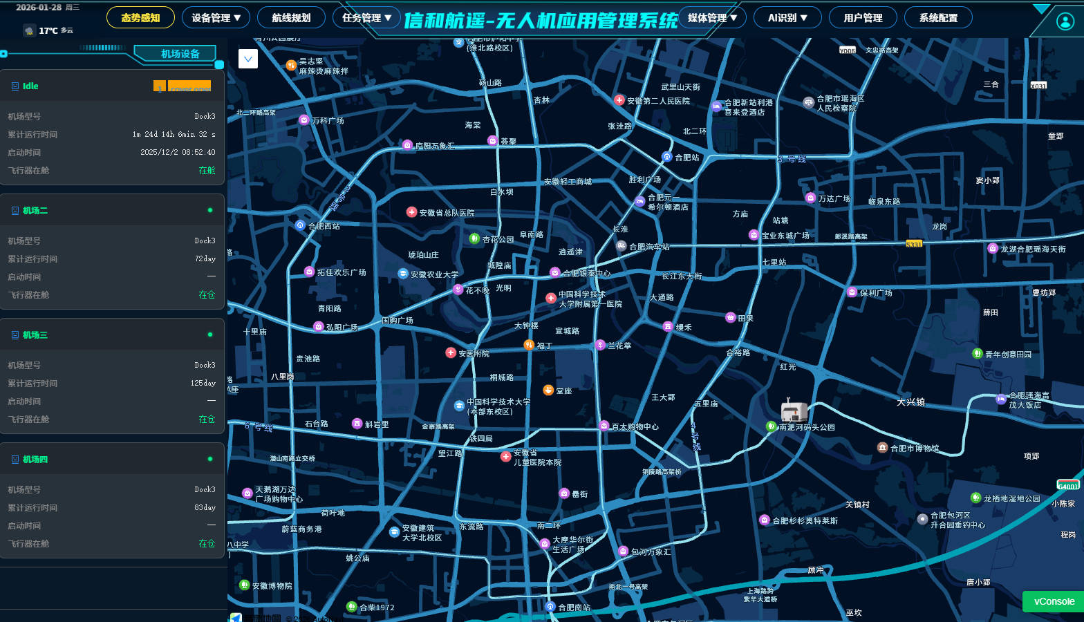
Application of Low-Altitude UAVs: Smartly Activating Low Altitudes, Achieving Efficiency Leap
Core keywords: Unattended inspection, AI recognition and alarm, multi-source data collectionAgainst the backdrop of the booming low-altitude economy, Xinhe Hangyao has reshaped the traditional "mass inspection" model into an intelligent automatic operation system through the in-depth integration of "unmanned aerial vehicles (UAVs) + AI". We provide full-stack services covering UAV equipment agency, UAV airport deployment, and self-developed intelligent inspection management systems.Relying on advanced oblique cameras, laser radars, and multispectral sensors, we can efficiently collect high-precision laser point clouds and panoramic images, providing real-time and intuitive frontline data for water administration law enforcement, river and lake inspections, power line patrols, and forest disaster prevention. The core competitiveness of the system lies in AI target detection and recognition technology, which can real-time identify illegal construction, fire hazards, or floating objects on the water surface and trigger intelligent alarms. Combined with route planning and unattended technology, we have realized the 定时 triggering of inspection tasks and real-time data image transmission, which not only greatly improves operational efficiency but also ensures closed-loop management and rapid response of supervision in complex environments.
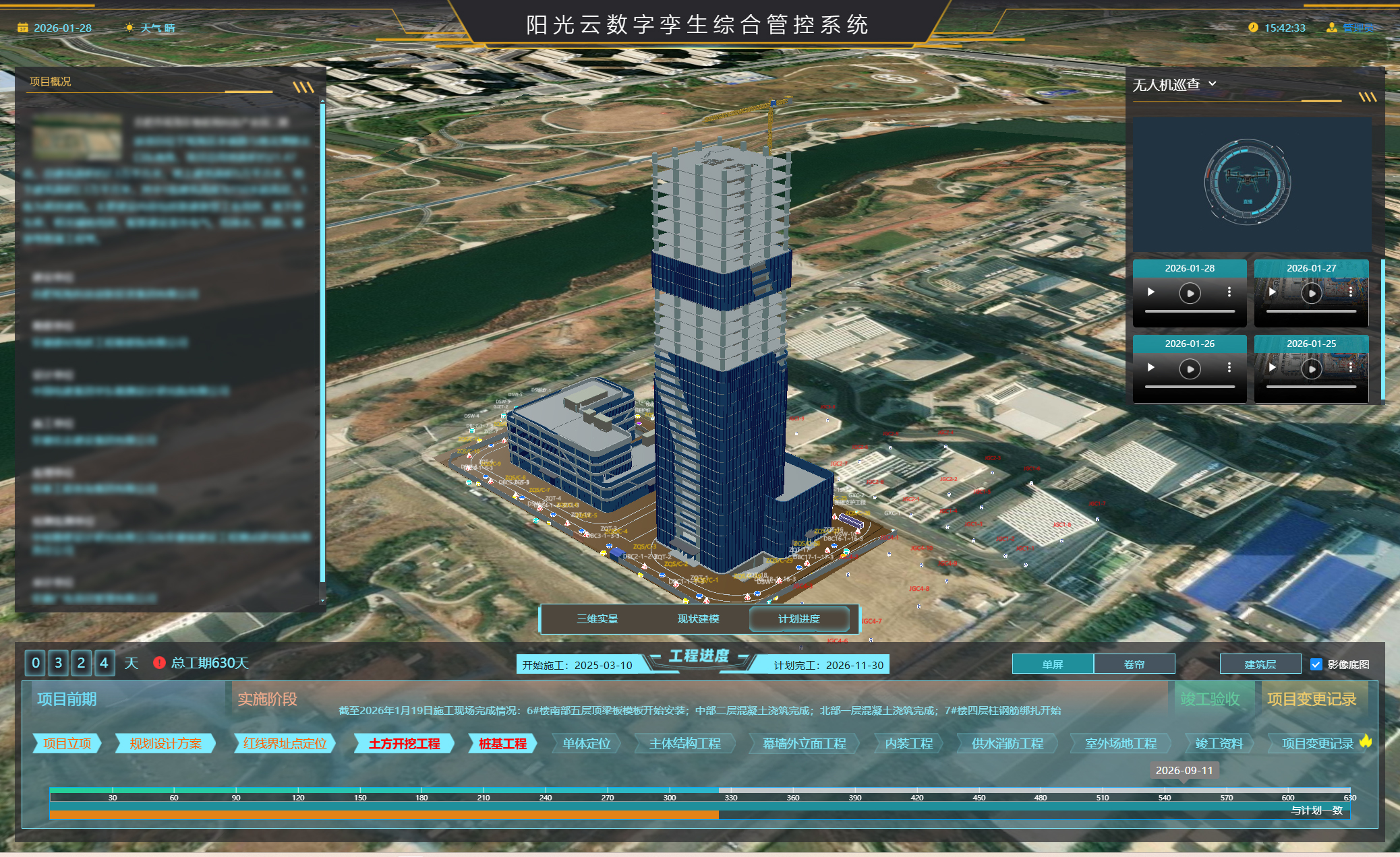
Digital Twin Display Service: Virtual-Real Mapping, Digital-Intelligent Symbiosis
Core keywords: multi-source heterogeneous base, real-scene 3D modeling, visual customization
Xinhe Hangyao closely follows the strategy of Digital China and is committed to creating a perfect mapping between the physical world and the digital space. We have an independently developed multi-source heterogeneous data bearing base with strong compatibility, which can deeply integrate satellite images, UAV oblique photography models, BIM architectural models and real-time sensing data from the Internet of Things, thus solving the problem of "information islands".
We provide a full-chain service from high-precision real-scene 3D model production to 3DMAX/BIM refined model production. Through highly realistic visual presentation, we build a delicate, realistic and coordinate-unified digital base. Based on this base, we custom-develop 3D visualization platforms for smart parks, digital cities, emergency command, etc., for government and enterprise customers. The platform not only supports dynamic display, but also integrates data analysis, simulation prediction and management scheduling functions, realizing "one screen to view the whole situation, one network to manage the whole area", and empowering urban refined management and enterprise digital transformation.

Surveying and Mapping Geographic Information Services: Rooted in the Earth, Striving for Excellence
Core keywords: surveying and mapping qualification, high-precision monitoring, full life cycle of the projectAs a national high-tech enterprise with professional surveying and mapping qualifications, Xinhe Hangyao has always been consolidating the digital foundation for various industries with accurate geographical information data. We have an experienced professional and technical team, equipped with advanced equipment such as surveying robots, high-precision GPS, unmanned boats and CCTV detection robots, and our business covers the entire field of basic surveying and mapping and special engineering surveying and mapping.In basic businesses such as territorial spatial planning and 3D cadastral survey, we ensure the authority and accuracy of every spatial data; in the fields of engineering deformation monitoring, water conservancy surveying and mapping, and complex underground pipeline network detection, we safeguard the safe operation of major projects through strict operation procedures and multi-method reviews. In addition, we use photogrammetry technology to provide progress tracking and quality monitoring for large-scale infrastructure construction. Xinhe Hangyao adheres to strict technical standards, combines traditional surveying and mapping with modern information technology, and contributes stable professional strength to national infrastructure construction and the development of the geographical information industry.