Based on the actual development of highway transportation, the company closely follows the industry trend of digital transformation and upgrading of transportation infrastructure. At the same time, it delves deeply into the field of low-altitude inspection and meets the high-quality development demands of various industries.
In response to the core pain points such as the expansion of the highway network scale, the heavy tasks of bridge maintenance and management, and the low inspection efficiency, high safety risks, and lack of data support in multiple industries, Build an integrated solution for intelligent inspection of unmanned aerial vehicles (UAVs) featuring "low-altitude UAV nests + multi-modal intelligent recognition + digital twins". The solution takes "1 platform +2 functions +N scenarios" as its core architecture, achieving a full-process closed-loop management from inspection, identification, assessment to decision-making, handling and archiving. It not only injects technological impetus into the maintenance of highways and Bridges, promoting the transformation of maintenance models towards intelligence, prevention and precision, but also can widely empower multiple fields such as water conservancy, power, forestry, environmental protection and construction. Break through the bottleneck of traditional inspection, and achieve quality improvement, cost reduction and risk control in inspection across the entire industry.
i.directly address the core pain points of inspection across the entire industry
At present, traditional manual inspection is still the main method for inspection in various industries. In some scenarios, a single device is used for inspection. There are widespread problems of "three highs and three lows" (high risk, high cost, high time consumption, low efficiency, low accuracy, and low coverage). Among them, the field of highway Bridges, due to its special scenarios, has more prominent pain points and can no longer meet the needs of modern management and maintenance and high-quality development of the industry.
(1) Common core pain points
Low efficiency and numerous blind spots in inspection: Traditional models such as "scaffolding + telescope", "vehicle-mounted high-power mirror", and "manual hiking/climbing" require the closure of operation areas and the construction of operation platforms when dealing with long-distance, large-scale, and complex terrain scenarios, which is time-consuming and cumbersome in process. The "blind spots" in various scenarios (such as under Bridges, at the top of towers, deep slopes, remote water areas, and deep mountain routes, etc.) are difficult to cover, and the rate of missed detections remains high.
High safety risks and large investment of human and material resources: Maintenance and inspection personnel need to work in dangerous environments such as high-speed traffic, high altitudes, water, and deep mountains. Under extreme weather conditions, the difficulty of inspection and safety risks increase sharply. Regular inspection requires a large number of personnel and vehicles. The long-term maintenance and inspection costs remain high, and the labor intensity is also high.
Scattered data and lack of quantitative support make it difficult to predict: Inspection relies on manual experience, and records of diseases and hidden dangers are mostly in paper form or simple photos, lacking quantitative data. It is impossible to form a continuous spatio-temporal data chain. The inspection data is disconnected from the management platform, making it difficult to accurately predict the development trend of potential hazards. Maintenance and handling often shift from "prevention" to "remediation", and the data cannot be quickly traced back. It is also difficult to trace the rectification.
Poor compatibility of equipment and lack of a full-process closed loop: In most industries, the existing inspection equipment has poor compatibility. The limitations of single-device inspection are obvious, and it is impossible to achieve multi-device collaborative operation. It is difficult to form a full-process closed loop of "inspection - identification - disposal - archiving", which greatly restricts the improvement of inspection work quality and efficiency.
(2) Specialized pain Points for Highway Bridges
In light of the actual management and maintenance of highway Bridges, for special scenarios such as high-pier and long-span Bridges, deep valleys and high slopes, and long-distance inspections of trunk roads, the following additional challenges exist: First, for areas like kilometer-level cross-river Bridges and deep valleys and slopes, inspection requires closing lanes and building operation platforms. It takes several days or even weeks for a single bridge, seriously affecting traffic flow. Second, in the face of climate differences such as low temperatures and abundant rainfall, the environmental adaptability of inspection equipment is required to be extremely high. Thirdly, the inspection of precision components such as bridge stay cables and bearings is difficult and requires manual assistance for inspection, resulting in low collaborative efficiency. Fourth, there is a lack of hazard data sets that are in line with the actual situation of highway Bridges, and the adaptability of AI recognition is insufficient.
(3) Pain points in multi-industry segmentation
Water affairs inspection (water administration law enforcement + river and lake patrol) : The water area is vast and the terrain is complex. Remote water areas are difficult for humans to reach. Illegal sand mining, illegal aquaculture, water pollution and other violations are highly concealed. The safety risks of water operations are high, and the efficiency of evidence collection and law enforcement is limited.
Power line inspection: Transmission lines have large spans and often pass through complex terrains such as mountainous areas and deserts. Manual climbing inspection is highly risky and labor-intensive. Minor hazards on the lines are easily overlooked by the naked eye, and the response to faults is lagging behind.
Forestry and environmental protection inspection: The forest area is vast and the vegetation is dense, making it difficult to detect and handle potential hazards such as fires and pests and diseases early. During environmental protection inspections, pollution points are concealed. Traditional detection methods are time-consuming and have insufficient data accuracy, making it impossible to achieve real-time monitoring and data linkage.
Construction supervision: Issues such as excessive dust on construction sites, illegal operations, and delayed progress make it difficult for manual supervision to achieve round-the-clock coverage. Inspection records are highly subjective and lack precise data support.
Agricultural inspection: The scope of agricultural scenarios such as farmlands, orchards, and greenhouses is vast. Manual inspection is time-consuming and labor-intensive, and the coverage is incomplete. Hidden dangers such as crop pests and diseases, abnormal growth, and damaged irrigation facilities are difficult to detect early, which can easily lead to reduced yields. The low accuracy of monitoring the soil moisture and fertility distribution in farmland leads to blind application of pesticides and chemical fertilizers, increasing costs and polluting the environment. Manual monitoring of parameters such as temperature, humidity and light transmittance in greenhouses is cumbersome and real-time regulation cannot be achieved.
Ii. Core Architecture of the Solution: 1 platform +2 functions +N scenarios, fully adapted to the demands of multiple industries in all dimensions
This solution takes machine nest networking coverage, multi-source data integration, intelligent recognition and early warning, and business closed-loop management as its core design principles. It builds a technical architecture of "1 comprehensive platform +2 core functions +N application scenarios", taking into account the special management and maintenance of highway Bridges and the inspection needs of multiple industries. It covers all types of inspection objects such as road surfaces, Bridges, slopes, traffic safety facilities, water areas, lines, construction sites, etc., and is adapted to the inspection needs of multiple scenarios such as national highways, expressways, extra-large Bridges, mountain roads, rivers and lakes, forests, and substations, achieving intelligent inspection across all industries, scenarios, and processes.
(i)Four-layer interactive architecture, fully integrated from data collection to intelligent application
The solution adopts a four-layer interactive design of "perception layer - edge layer - platform layer - application layer", breaking down data barriers and achieving full-chain integration from data collection, transmission, analysis to application, taking into account both specialization and universality: Perception layer: Adopting DJI industrial-grade drone nests (including Matrice4TD drones), it supports dual-mode shooting of visible light and infrared, achieving multi-modal data collection. According to the demands of different industries, it can flexibly match and adapt equipment to meet the data collection needs of various types such as highway bridge diseases, power line hazards, water area violations, and forest fires, and is suitable for inspection in complex scenarios. Edge layer: Equipped with high-performance AI servers, live streaming servers, database servers and high-speed networks, it ensures real-time data transmission and efficient computing. Support real-time analysis of lightweight AI models at the edge, enabling rapid marking of potential risks, reducing data transmission pressure, and enhancing response efficiency. Platform layer: Build a three-in-one platform of "business middle platform +AI algorithm middle platform + data middle platform" to achieve core functions such as task flow management, intelligent identification of diseases and hidden dangers, massive data storage and analysis, and multi-device collaborative scheduling. Support integration with the customer's existing management platform to achieve data linkage and sharing, and adapt to the management needs of various industries. Application layer: Centered on the "Highway Daily Maintenance Unmanned Aerial Vehicle Inspection System", it extends and expands multi-industry inspection modules, supports dual deployment in the cloud and privately, and ADAPTS to the management needs of different industries and levels such as maintenance units, water departments, power companies, and forestry departments, achieving the management of all industries' inspections on one platform.
(ii) Hardware deployment: Industrial-grade configuration, adapted to complex climates and multiple scenarios
The hardware adopts industrial-grade standard configuration, taking into account the climate differences between northern and southern Anhui and the complex needs of various industries, enabling all-weather, all-scenario unattended operation and lowering the threshold for implementation.
DJI Airport 3 Drone Nest: An industry-leading, integrated industrial-grade drone nest equipped with the built-in Matrice 4TD drone. It features an IP56 protection rating and a wide operating temperature range from -30℃ to 50℃, capable of withstanding strong winds up to 12 meters per second and freezing rain. It’s perfectly suited to adapt to the climatic differences between northern Anhui’s cold winters and southern Anhui’s rainy conditions, while also performing well in challenging environments such as deep mountains and aquatic areas. The built-in air conditioning system preheats batteries for stable charging even in high temperatures. It integrates line-of-sight obstacle avoidance radar, enabling millimeter-level precision obstacle avoidance at a flight speed of just 15 seconds. Deployment requires only ground-based installation plus power and network connectivity, making it ideal for unattended, high-frequency inspections.
Comprehensive Server and Network Support: Equipped withAI servers (which can be replaced with edge computing devices), live-streaming servers, database servers, and more, ensuring efficient operation ofrecognition, real-time image transmission, and data storage;AI servers (which can be replaced with edge computing devices), live-streaming servers, database servers, and more, ensuring efficient operation of Drones are fitted with4Gmodules, and the drone nests are connected to municipal power grids+high-speed fiber optics, enabling high-speed transmission of inspection data and real-time communication between the drone nests and the backend system, thereby addressing issues such as poor signal coverage and slow data transmission in remote areas.
Multi-industry compatible accessories: Flexible combinations of infrared thermal imaging lenses, high-definition zoom lenses, loudspeakers, and other accessories can be tailored to meet the specific needs of various industries, such as temperature measurement for power lines, public address enforcement in waterways, and forest fire monitoring.
(3) Core System Functions: Seven basic modules+multi-industry customized modules, enabling end-to-end automation
Based on the daily maintenance drone inspection system for highways, we will expand its adaptability to multiple industries and build a closed-loop management system encompassing: “daily inspections → hazard identification → task assignment → on-site handling → review and acceptance → data archiving.” The main interface allows real-time viewing of drone stations, drone statuses, and inspection progress across various industries on a satellite base map. The core functions strike a balance between generality and customization.
1.Seven core basic modules (universal across all industries)
Device Management: Remote drone debugging (power on/off, charging, cabin door switching), firmware upgrades, unblocking, real-time viewing of device operating data, support for collaborative management of multiple drones, overcoming the limitations of single-device inspections.
Flight Route and Task Management: Online planning/import flight routes, support scheduled/immediate inspections; tasks can be paused, returned to base, or resumed from breakpoints. CombiningGPS/Beidou navigation with visualSLAMtechnology, it achieves precise positioning even in environments without signal coverage, automatically avoids obstacles, supports repeated calls and flexible adjustments, and is adaptable to diverse inspection needs across multiple industries.
Real-time image transmission: Real-time video feed from the drone, supporting1/4/6/9video windows displayed on a large screen. The footage can be scanned and live-streamed for sharing, enabling viewers to“watch the scene without leaving home”thus providing support for inspection and evidence collection.
Remote Control: One-click takeoff, remote control flight, point-and-fly mode; supports gimbal adjustment, camera switching, and remote voice announcements. When detecting violations or safety hazards, it can issue real-time remote warnings to enhance the timeliness of response.
Data Management: Unified management of photos, videos, panoramic images, orthophotos, and 3D models; supports multi-period data comparison, encrypted data storage, and traceability, addressing the issues of fragmented and untraceable traditional data.
User permission management: Customized functional permissions by department/position/ and industry module, tailored to meet the hierarchical management needs of various industries, ensuring data security and operational compliance.
Task management: Automatically generates work orders for potential hazards, dispatches them via app or SMS, tracks the handling process in real time, and closes the loop with acceptance checks, thereby standardizing inspection management.
2.Two core feature highlights (specialized empowerment, adaptable to all industries)
Smart Recognition: Precise Quantification and Customized Adaptation for Multiple Industries: Developed through deep customization based on the YOLO series architecture, this solution integrates multi-modal data fusion technology. On one hand, it builds a specialized dataset of road and bridge defects unique to Anhui Province—covering various seasons, lighting conditions, and weather types. On the other hand, it tailors exclusive recognition models to meet the specific needs of multiple industries, including water management, power supply, forestry, and others. By leveraging data augmentation to enhance model robustness and employing cross-modal fusion of infrared + visible-light images, the system can identify a wide range of potential hazards—including pavement cracks / potholes, slope collapses, damage to traffic safety facilities, exposed rebar in bridges, cracking, insulator damage, broken wire strands, illegal sand mining, fire risks, excessive dust levels, and more. The system automatically labels the type, location, and dimensions of these hazards and assigns severity levels—light, medium, or severe—according to national standards and industry-specific criteria. It generates structured reports with an accuracy rate of ≥95% for road and bridge defect detection and ≥90% for multi-industry hazard identification.
Digital Twin System: Visualized Management, Empowering the Entire Lifecycle—Using UAV oblique photogrammetry technology, the system generates realistic 3D models of inspection objects such as highways, bridges, transmission lines, and construction sites, thereby establishing digital twin archives. After each inspection, the system automatically generates orthophotos and720-degree panoramas. All data is linked to a timeline, enabling overlay comparisons between orthophotos and 3D models. This allows for intuitive tracking of hazard development and assessment of remediation effectiveness. Hazard locations are precisely mapped onto the 3D model; clicking on a location instantly retrieves the original imagery, analysis results, and historical data. This system not only supports comprehensive lifecycle management of bridges but also adapts to the visualized management needs of various scenarios, including power lines, reservoirs, and construction sites.
3.Multi-industry custom modules (adapted on demand)
Highway Bridge Special Module: New features include automatic calculation of the MQI index, adaptation to three types of bridge inspections (routine/regular/frequent), and auxiliary functions for inspecting precision components such as cable-stayed cable bearings. The module is aligned with the 'Technical Guidelines for Highway Bridge Inspection Using Low-Altitude Unmanned Aerial Vehicles' and the 'Highway Bridge and Culvert Maintenance Specifications' (JTG5120-2021).
Water Resources Enforcement Module: New features include evidence collection and archiving of violations, integration with enforcement workflows, and precise positioning of water area boundaries, helping to enhance the efficiency of water administration law enforcement.
Power Inspection Module: Added functions for line temperature measurement, tree-obstacle distance calculation, and fault location, helping to avoid risks associated with high-altitude operations and ensuring the safety of the power system.
Forestry and Environmental Protection Module: Added features for rapid fire alerts, area estimation of pests and diseases, and pollution concentration analysis, enabling early detection and prompt response.
Agricultural Inspection Module: Added features for crop growth monitoring, precise identification of pests and diseases, farmland soil moisture detection, irrigation facility inspection, and greenhouse environment monitoring. Supports the generation of crop growth analysis reports, pest and disease management recommendations, and soil moisture regulation plans, catering to the needs of large-scale and precision agriculture and boosting the development of smart agriculture.
(4) Core workflow: A five-step closed-loop system, universally applicable and adaptable to all industries
The solution adheres to the principles of automation, intelligence, and closed-loop operation, and features a five-step core workflow that can be flexibly adjusted according to the needs of various industries, enabling a fully automated closed loop from inspection to handling and significantly reducing manual intervention:
Task scheduling and automated inspection: Tasks are dispatched according to preset frequencies for each industry (e.g., highways and bridges once daily, forests weekly), and drones automatically take off, perform inspections, return to base, and recharge—all without human supervision. This approach is adaptable to the varying inspection frequency requirements across multiple industries.
Multi-modal Data Acquisition and Real-time Recognition: Synchronously acquire high-definition/infrared data, with a lightweight AI model deployed at the edge for real-time analysis, marking potential hazards and generating preliminary reports, enabling rapid hazard identification and improving response efficiency.
Cloud-based Analysis and Precise Assessment: Upload data to the cloud for precise quantification of hazards, automatically calculate relevant indices (such as the highwayMQI index) according to national and industry standards, generate trend charts, and provide data support for hazard prediction.
One-click dispatch of maintenance and disposal tasks: After confirming potential hazards, work orders are automatically generated, precisely located, and dispatched to the corresponding teams and departments. During the disposal process, photos can be uploaded and the progress tracked in real time, ensuring that hazards are addressed promptly.
Automatic review and archiving of disposal results: During the next inspection,AIautomatically compares pre- and post-disposal images, feeds back acceptance results to the system, and archives the data into the asset’s full lifecycle archive, thereby establishing aPDCAclosed loop and achieving standardization and normalization of inspection work.
(5)N application scenarios: Focusing on empowering highway bridges, with broad coverage across multiple industries
1. Specialized application for highway bridges (core scenario, tailored to Anhui’s actual conditions)
Based on the “Technical Guidelines for Low-Altitude UAV Application in Highway Bridge Inspection” and the “Highway Bridge and Culvert Maintenance Specifications” (JTG5120-2021), we address the three types of routine/regular and periodic inspection requirements for bridges, achieving precise complementarity between UAV-based and manual inspections, and tailoring our solutions to meet the maintenance needs of special large bridges, bridge clusters, trunk highways, mountainous roads, and other similar infrastructure in Anhui Province:
Daily Inspection: The drone nest enables high-frequency inspections—1 time per day—covering the bridge deck, guardrails, signs and markings, bridge protection zones, road surface, and slopes, allowing for rapid identification of obvious hazards.
Regular Inspection: The drone conducts inspections 1 time per month, identifying defects such as cracks and spalling on the bridge deck, missing railings, potholes in the road surface, and slope failures. Precise components like cable stays/ bearings are inspected with human assistance to enhance collaborative efficiency.
Regular Inspections: Once every 3 years1, the drone conducts a comprehensive inspection according to daily/regular inspection procedures. Potential hazards such as structural deformation and displacement are detected using conventional methods. The system implements a closed-loop process for hazard marking, assignment, rectification, and review, thereby creating a complete inspection record.
2.Expanded Applications Across Multiple Industries (General Scenarios, Adaptable on Demand)
Water Resources Inspection (Water Administration Law Enforcement + River and Lake Patrol): Suitable for inspecting various types of water bodies, including rivers, lakes, reservoirs, and more; identifies issues such as water pollution, illegal aquaculture, and unauthorized sand mining; enables rapid evidence collection and real-time verbal warnings; achieves full-coverage inspection of water bodies and solves the challenge of inspecting remote water areas.
Power Line Inspection: Suitable for inspection scenarios such as high-voltage transmission lines and substations, it replaces manual climbing inspections, eliminates the risks associated with working at heights, precisely identifies potential line hazards, and enables intelligent and efficient line inspection, thereby ensuring the safe and stable operation of the power system.
Forestry and Environmental Inspection: Achieve comprehensive forest inspections, quickly identify potential fire hazards and pest/disease risks, enabling early detection and prompt response to minimize disaster losses; also suitable for environmental monitoring scenarios, providing real-time monitoring of air, water, and soil pollution, accurately pinpointing pollution sources, and offering data support for environmental governance.
Construction Supervision: Implement 24-hour monitoring of construction sites, effectively controlling issues such as excessive dust emissions and non-compliant operations. Simultaneously monitor construction progress, supporting safety and quality management on-site and overcoming the limitations of manual supervision.
Agricultural inspection: Compatible with agricultural scenarios such as grain crop fields, economic crop gardens, facility agriculture (greenhouses), and irrigation pipe networks, achieving full-domain and full-coverage inspection. By using both visible light and infrared dual modes, it monitors the growth of crops such as wheat, rice, fruits and vegetables, accurately identifies abnormal conditions like pests and diseases, weeds, and nutrient deficiency in crops, and checks for problems such as damaged and clogged irrigation pipelines. Real-time monitoring of temperature, humidity and light transmission in greenhouses, automatic generation of inspection reports and production guidance suggestions, helps farmers apply fertilizers precisely, carry out scientific prevention and control, reduce production costs, increase crop yields and quality, and promote the transformation of traditional agriculture to smart agriculture.
III. Core Values: Empower the entire industry with technology to improve inspection quality, reduce costs, and control risks
The solution balances specialized maintenance and management of highway bridges with multi-industry inspection needs, focusing on core pain points to deliver comprehensive value to customers across various industries. It particularly aligns with the actual development of highway transportation in Anhui Province while empowering high-quality development across multiple sectors:
Significant efficiency gains and breakthroughs in addressing blind spots: Drones replace manual labor to complete over 80% of inspection tasks. They can perform 1 automated inspection per day, reducing the inspection time for kilometer-scale bridges from several days to just a few hours. Inspection efficiency across multiple industries has increased by 5-30 times compared to traditional manual methods, completely eliminating various inspection blind spots and achieving full-coverage inspections.
Accurate and efficient identification, driving proactive intervention: multimodalAI precisely quantifies potential hazards. The accuracy rate for identifying defects in highways and bridges reaches≥95%, and the accuracy rate for identifying hazards across multiple industries is≥90%. By integrating historical data, we can predict trends in hazard development, enabling highway and bridge maintenance as well as multi-industry inspections to shift from“reactive remediation”to “proactive prevention,” thereby reducing the risk of hazards escalating.
Zero safety risks, significantly reduced maintenance costs: Drones replace human workers in hazardous environments such as high altitudes, high speeds, water bodies, and deep mountains, eliminating safety hazards at the source. At the same time, this reduces the need for manpower and vehicles, cutting long-term maintenance costs for highways and bridges by more than 60%. Inspection costs across multiple industries have been drastically reduced, achieving cost savings and efficiency gains.
Digital twin visualization for full-lifecycle management: Establish digital twin profiles for inspection objects across various industries, enabling intuitive comparison of multi-period data to track potential hazards and evaluate the effectiveness of remediation efforts. This provides precise data support for maintenance and inspection decision-making, achieving standardized management throughout the entire lifecycle.
Adaptable to multiple industries with low implementation barriers: One platform covers all industry scenarios, allowing customization of features based on specific industry needs. It’s easy to operate and requires no specialized drone piloting or data analysis expertise—staff can get started after just a brief training. It supports both cloud-based and private deployment options and can seamlessly integrate with existing management platforms for rapid implementation.
Local services in Anhui, ensuring rapid response and support: Based in Anhui, our company has built a localized technical service team, achieving on-site response within 2 hours in Hefei and within 12 hours in remote areas across Anhui Province, thereby guaranteeing stable system operation and addressing operational and maintenance concerns for customers across various industries.
IV. Full-Cycle Service Assurance: Build it well, use it effectively, and manage it securely—worry-free after-sales service for the entire industry
The company has built a multi-level, full-lifecycle, scenario-based training and operation & maintenance system that caters to the needs of both highway and bridge projects as well as clients from various industries, ensuring the long-term stability of the system and enabling clients across all sectors to “everyone can use it easily, use it in compliance with standards, and enjoy worry-free operation and maintenance”:
(1) Tiered and Categorized Specialized Training
Management Training: Explains system architecture, business processes, and decision-support features, with demonstrations using case studies from various industries such as highways, bridges, water resources, and power, to enhance the scientific nature of management and decision-making.
Technical Staff Training: Provides hands-on training in skills such as drone base station scheduling, flight route planning,AI result review, and equipment maintenance. Organizes simulation exercises across multiple industry scenarios to ensure that technical staff can operate independently and resolve common issues.
(II)24/7 all-day technical support
Phone Response≤10 minutes: A professional engineer provides a preliminary diagnosis and remote guidance to quickly resolve various operational questions;
Remote Support≤30 minutes: Resolves issues such as software configuration and data anomalies, ensuring the system runs smoothly;
On-site Response: Hefei≤2 hours; Remote areas in Anhui≤12 hours. We carry spare parts to swiftly address hardware failures while meeting the needs of customers across all industries within the province.
(3) Full-cycle maintenance and long-term service
1 year of free all-inclusive maintenance: Starting from the date of acceptance and qualification, we provide12 months of free maintenance, covering repairs/replacements for non-human-induced software and hardware damage, AI algorithm optimization, and system performance tuning; plusmonthly remote health checks to monitor key metrics such as device status, network conditions, and recognition accuracy.
Long-term service mechanism: After the warranty period ends, you can sign an annual operation and maintenance agreement to enjoy value-added services such as priority response, discounted spare parts, and a dedicated account manager. We will continue to optimize system features and algorithm models, adapt to new industry development needs, and deliver long-term value creation.
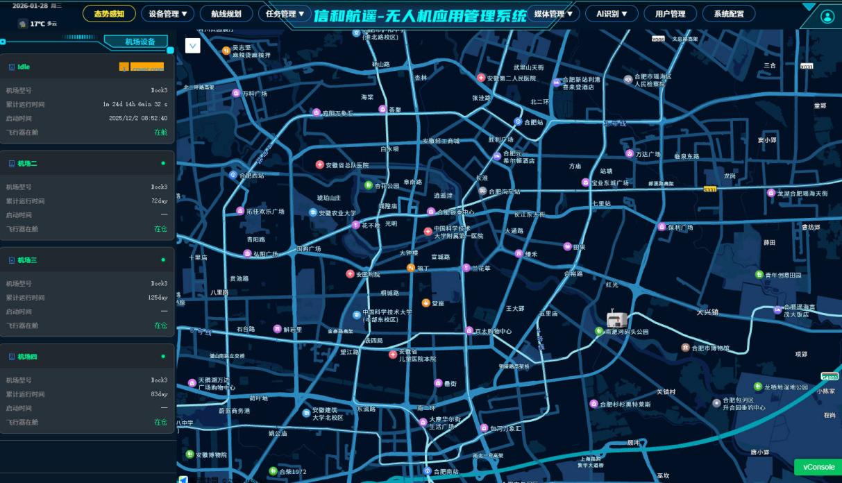
System Main Interface
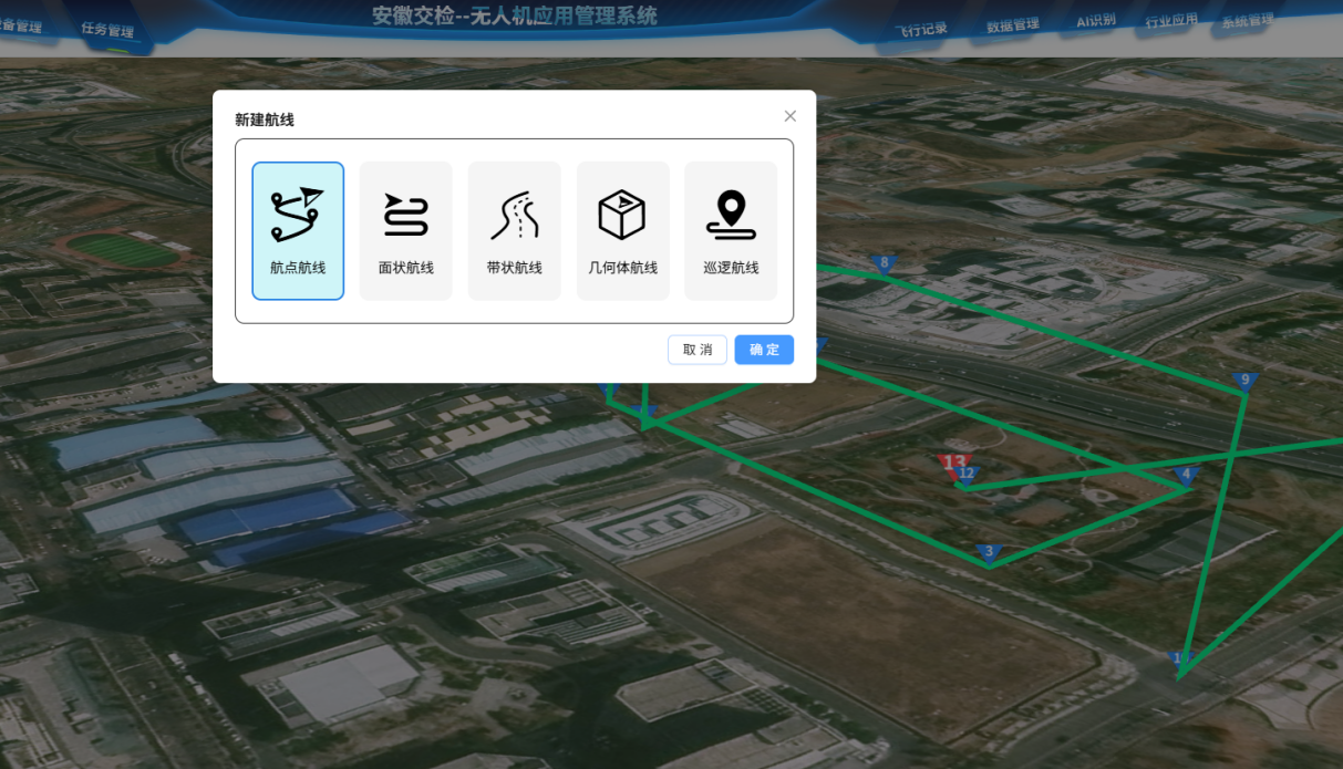
Route Management
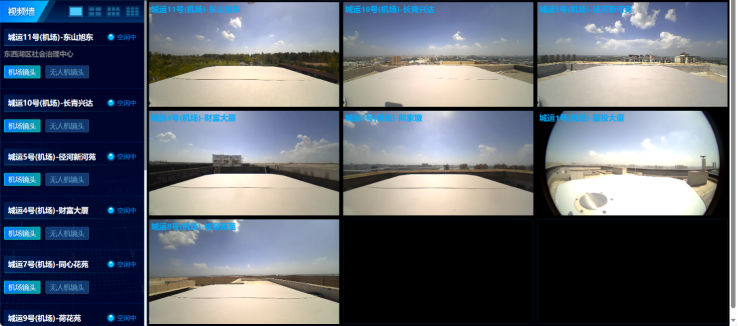
Real-time image transmission
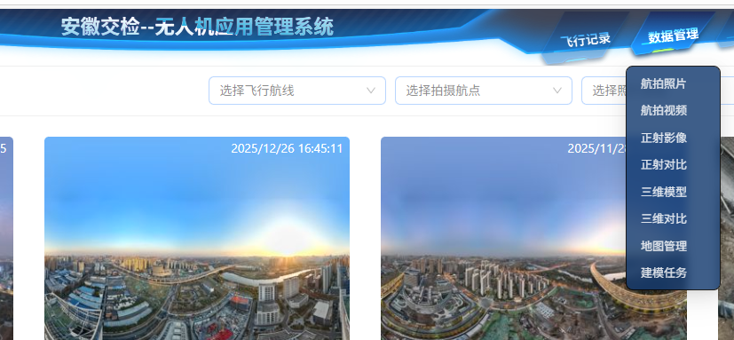
数据管理
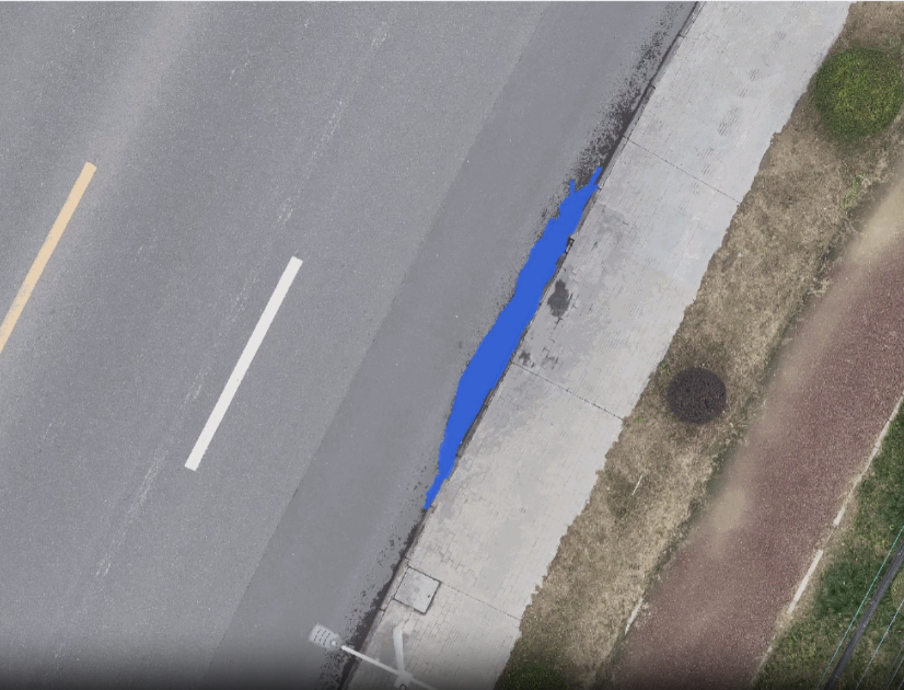
AI Intelligent Identification of Road Hazards
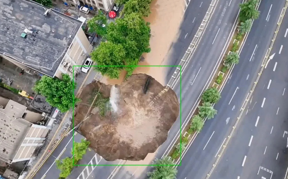
AI Intelligent Detection of Road Waterlogging
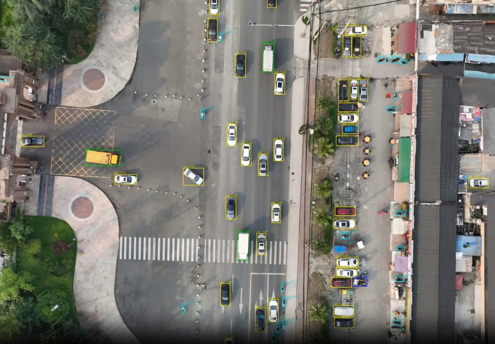
AI Intelligent Vehicle Recognition
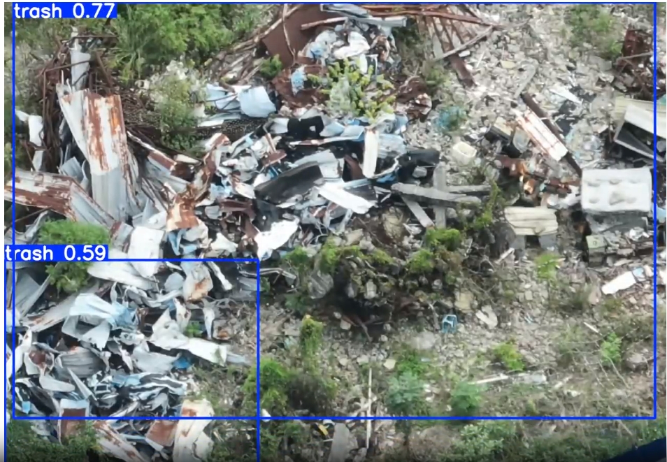
AI Smart Recognition of Waste
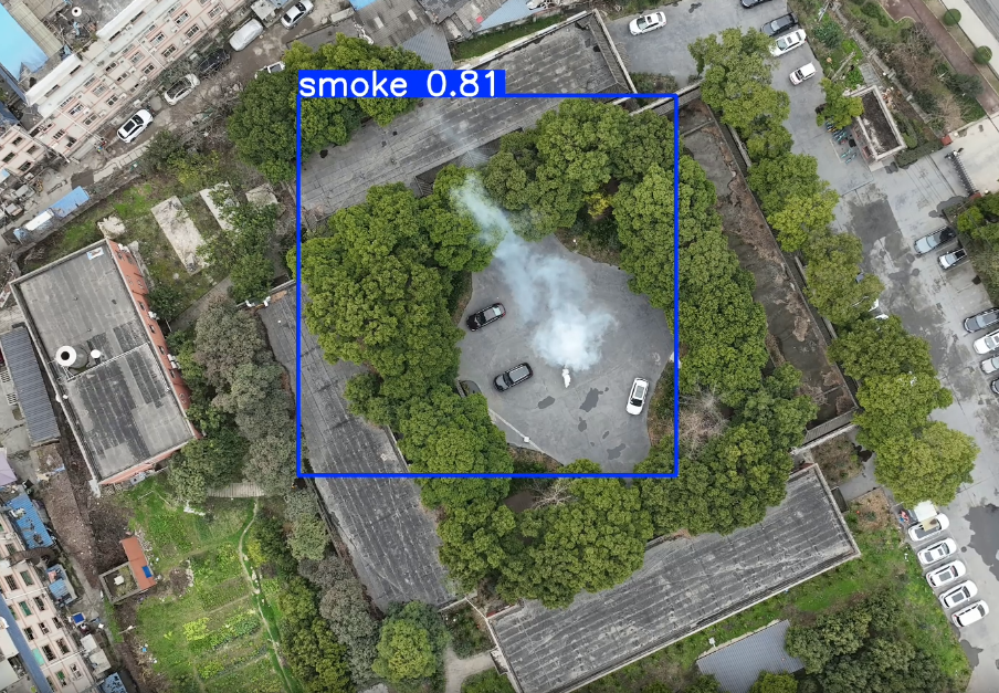
AI Smart Smoke Detection
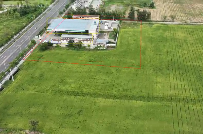
AI Intelligent Identification of Changes in Cultivated Land
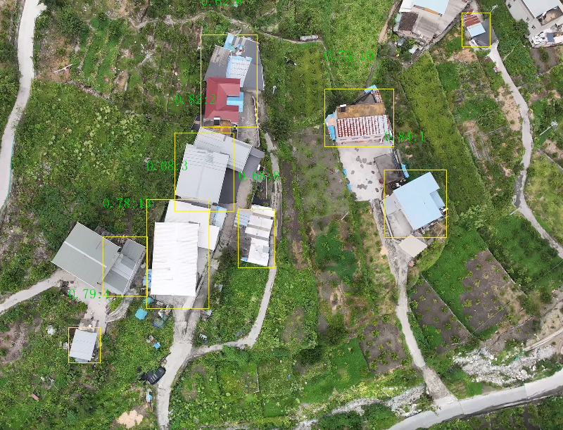
AI Intelligent Building Recognition
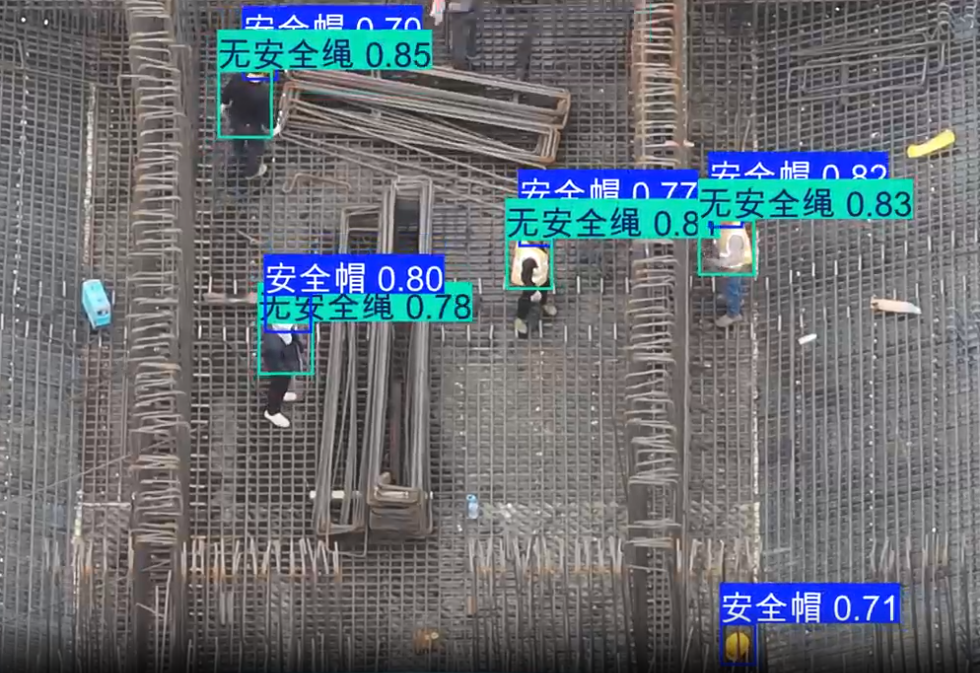
AI Intelligent security check