The traditional mine monitoring relies on manual inspection and single-point equipment detection, which has the pain points of large monitoring blind area, lagging data, low efficiency and high safety risk, it is difficult to deal with hidden hazards such as slope landslide, surface subsidence, tailings pond siltation and ground fissures, and it can not meet the multiple requirements of mine safety production, Green Governance and compliance supervision.
Based on the development trend of the industry and the relevant laws and regulations of National Mine Safety, our company has created a four-in-one mine total factor monitoring and early warning solution of air-air-ground-water, integrating four core technologies of satellite remote sensing, unmanned aerial vehicle inspection, ground precision monitoring and underwater surveying and mapping, and matching with the real-life three-dimensional digital twin platform, the mine can realize global, full-time and high-precision intelligent monitoring, it will help the mine to realize the modern operation mode of“Mining, monitoring and treatment at the same time”, and escort the safe production, ecological restoration and compliance acceptance of the mine.
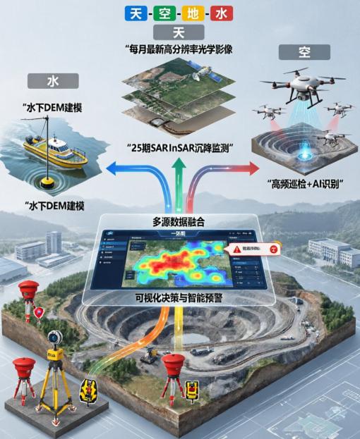
The four dimensions work together to build a global three-dimensional monitoring network. We break the bottleneck of the separation of traditional monitoring dimensions and create a closed-loop monitoring system of“Wide-area census-detailed investigation-precise verification-underwater blinding”, the four plates perform their respective duties, data exchange, all-round coverage of the mine land, water all monitoring scenarios.
Space-based view: satellite remote sensing, millimeter-scale global subsidence survey
Taking satellite remote sensing as the macro monitoring core, the global geographic datum of the mine is built to realize the normalized monitoring of large-scale surface change and deformation.
1. Dynamic base map update: the domestic high-resolution optical satellite images with a resolution better than 0.8 meters are obtained monthly. After ortho-correction and fusion enhancement processing, the real-time monitoring base map of the mining area is generated. The system can automatically identify and mark abnormal areas such as surface subsidence, ground fissures, and abnormal changes in dumps, accurately record the change area and latitude and longitude coordinates, and form a traceable and exportable“Change map”, it supports the comparison of historical images, so that the surface changes can be seen at a glance.
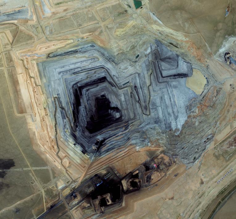
Yami image of a tin mine in Inner Mongolia
2. Time series subsidence monitoring: 25 C/X band SAR satellite images are obtained throughout the year, and the large-scale millimeter-scale deformation survey of the mining area is completed by using PS-InSAR and SBAS time-series interferometric radar technology, the surface deformation rate and cumulative settlement are accurately extracted to generate the distribution map of the settlement funnel and the deformation time series curve. Combined with the overlay analysis of optical base map, the high-risk hidden danger target area can be quickly delineated, and the early prediction of major disasters such as landslides and collapses can be realized, which fully meets the high-frequency monitoring requirements of the National Mine Safety Supervision Bureau.
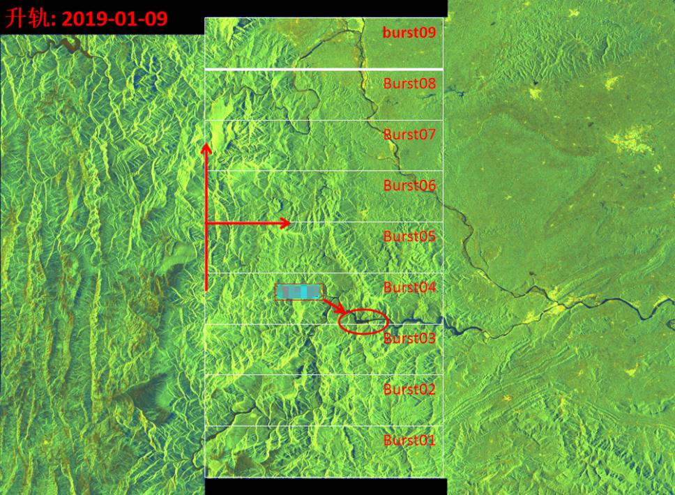
Burst band of surface deformation monitoring in an Insar in Yunnan province
Air-based inspection: UAV Nest, AI intelligent refined investigation
In view of the risk areas delineated by satellites, the high-frequency refined inspection is carried out by relying on the unmanned UAV nest system to complement the details of macro-monitoring. Fully automatic UAV airport deployment, equipment can be independently completed take-off and landing, charging, route planning, without manual field operation. The UAV is equipped with a high-definition optical camera and an airborne LiDAR. A single flight can cover 15 km2 of key areas, and collect centimeter-level orthophoto, oblique photography model and 3 D point cloud data.
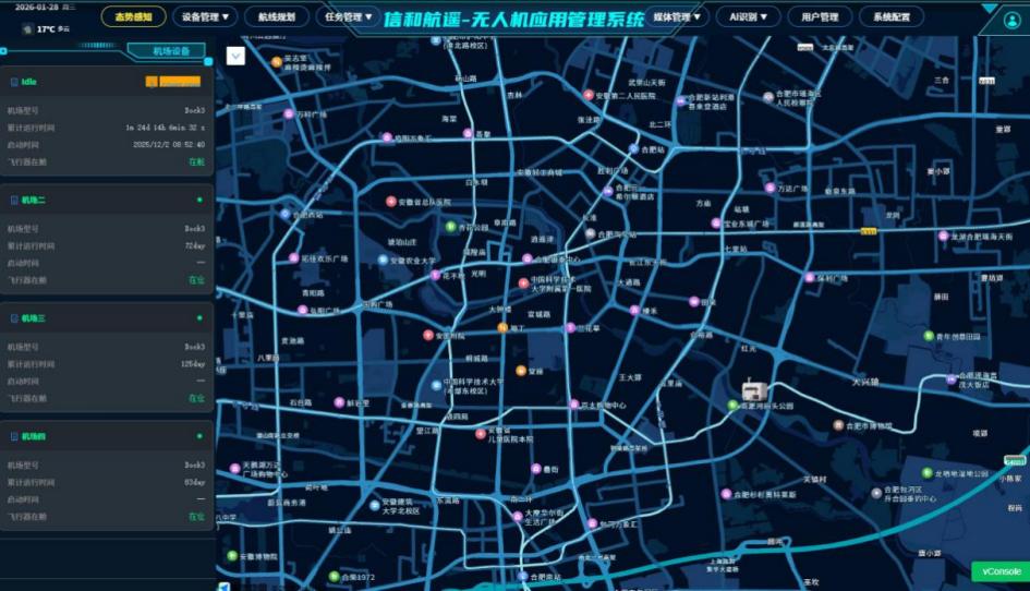
Patrol inspection system of unmanned aerial vehicle
Equipped with the self-developed AI recognition algorithm, it can automatically identify hidden dangers such as slope cracks, landslides, and illegal occupation, generate a standardized list of hidden dangers in real time and synchronize it to the management platform. Whether it is a complex steep slope, a dangerous stope, or a harsh environment such as rain and strong wind, the UAV can operate flexibly and completely replace the high-risk manual inspection. The inspection efficiency is more than 10 times higher than that of the traditional method.
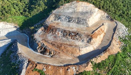
Mine monitoring by UAV
Foundation precision measurement: double equipment linkage, 24-hour real-time monitoring of slope
Focusing on the high-risk slopes and key sections of the mine, the GNSS continuous observation system and the Leica high-precision measurement robot are used for complementary monitoring to realize all-weather accurate control of three-dimensional displacement.
GNSS continuous observation station: Based on Beidou high-precision positioning technology, deployed in the core area of the slope, uploads 3 d displacement data in real time at 1 Hz high frequency, and continuously captures the micro deformation dynamics of the slope, the data is accessed to the cloud platform through 4G/5G low-latency.
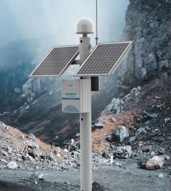
GNSS continuous observation system
Leicatm60/TM50 measuring robot: equipped with reflective PRISM to carry out automatic polar coordinate measurement, angle measurement accuracy of 0.5′′ , ranging accuracy of 0.6 mm + 1 ppm, with IP55 protection capability, it can work stably in rain, snow, dust, low temperature and other complex conditions.
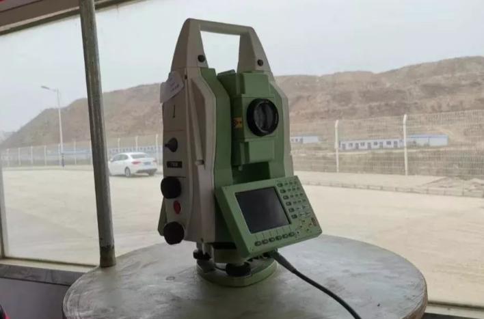
Leica measuring robot
Cross-validation of two sets of equipment data, once the displacement value exceeds the safety threshold, the system immediately triggers the three-level warning of SMS, sound and light, and platform pop-up window, and synchronously generates the disposal work order, realize the full closed-loop management of hidden danger from discovery, early warning to rectification, and firmly hold the bottom line of slope safety.
Water mapping: unmanned ship operation, underwater digital modeling of tailings pond
Aiming at the blind area of water area such as tailings pond and coal mining subsidence water area, the intelligent unmanned ship is equipped with dual-frequency sounding instrument to complete underwater topographic mapping, which fills the blank of traditional monitoring water area data. The unmanned ship can navigate autonomously according to the preset route and avoid obstacles intelligently. The dual-frequency Echo Sounder takes into account the advantages of high and low frequency detection: the high frequency 200 khz realizes fine scanning of the hard bottom, and the low frequency 33 khz penetrates the soft silt layer, high-density bathymetric point clouds are collected to build centimeter-scale underwater dems.
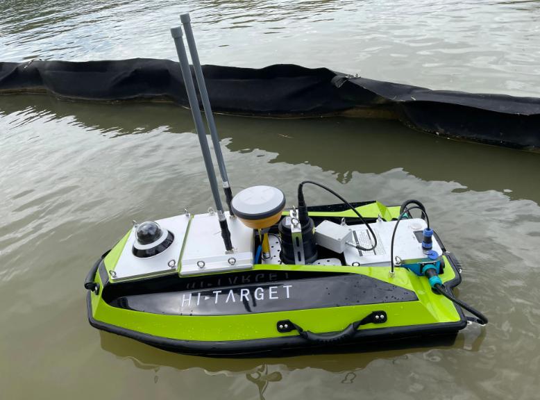
Unmanned ship (in operation)
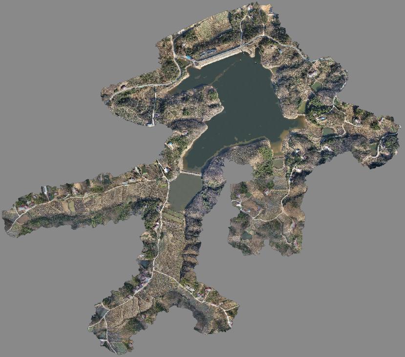
Three-dimensional model of a reservoir in Anhui province
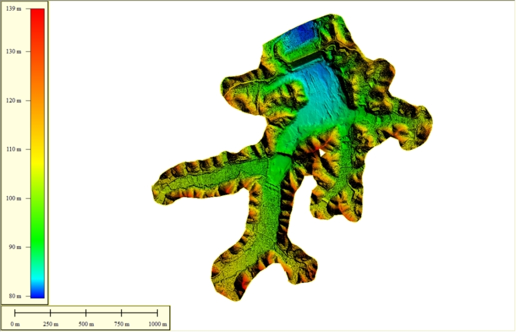
Dem (Digital Elevation Model) of a reservoir in Anhui
Combined with real-time water level data, the system dynamically calculates the change of tailings reservoir capacity and the rate of sediment deposition, and accurately evaluates the safe operation state of the water area. At the same time, the underwater terrain data and the three-dimensional model of the land scene are seamlessly integrated to create an integrated digital base for water and land, which provides quantitative data support for tailings pond dredging, water ecological management and safety acceptance.
Data fusion middle platform: real three-dimensional“One map”, intelligent decision-making center
We will unify the space-time datum of multi-source heterogeneous data of sky, air, ground and water, build a three-dimensional digital twin visualization platform for real-life mining areas, and truly realize the transformation of“Data island” to“Global sharing”, building an integrated management and control decision-making center.
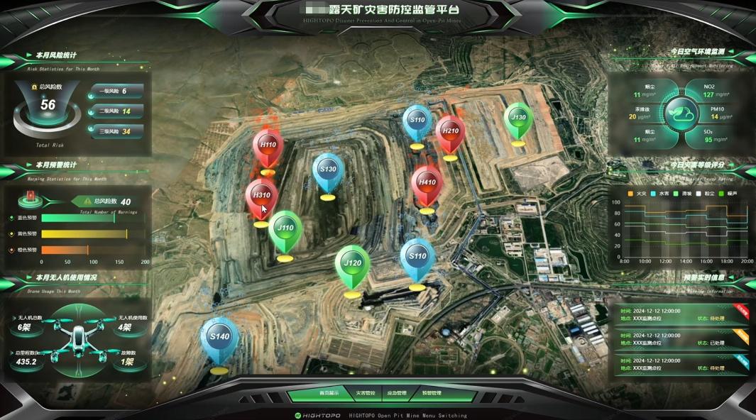
A sketch map of Management
Core features highlights:
1.Interactive 3D scene: click on any point of the 3D model, you can quickly access the settlement curve, historical images, real-time monitoring data, accurate coordinates, one-button automatic generation of monitoring reports, simplify office processes.
2. Dynamic deduction analysis: Based on the time series monitoring data, the evolution of settlement funnel and the displacement trend of slope are simulated, and the video playback of synchronous linkage UAV inspection is carried out to intuitively deduce the development trend of hidden dangers and assist risk judgment.
3. Full-dimensional data management: integrating core data such as base map timeline, Insar settlement rate, prism point displacement, and tailings pond volume to support full life cycle data backtracking and coordinate export, complete retention monitoring evidence chain.
4. Compliance traceability guarantee: the whole system strictly follows national and industry standards, and the monitoring data can support the use of mine safety funds, the restoration and acceptance of environmental governance, and the construction of green mines throughout the process, to meet all the requirements of compliance supervision.
The core value of the scheme empowers the digital and intelligent transformation of the mine
Compared with the traditional manual monitoring and single equipment monitoring mode, our sky-ground-water integration scheme has prominent advantages, enabling mines from five dimensions: safety, efficiency, cost, compliance and ecology:
1. Safety upgrading and preventive measures: early identification of hidden disaster-causing factors, early warning of major risks such as landslides, subsidence and tailings dam break, 24-hour All-weather three-dimensional protection, and reduction of accident rates.
2. Reduce costs and efficiency, simplify operation and maintenance: greatly reduce field manual operations, reduce overall operation and maintenance costs by 50% , and automate the whole process of monitoring, analysis and early warning, labor input and Operation Risk are both reduced. Sichuan Bureau of State Administration of Mine Safety.
3. Data-driven, scientific decision-making: digital twin“One map” visual management and control, all monitoring data visual display, farewell to empirical management, so that production, governance and scheduling decisions are more accurate.
4. Compliance and traceability: complete matching of Mine Safety Supervision, environmental management, fund management and other policy requirements, the whole process data retention, easy to deal with all kinds of inspection and acceptance.
5. Green development, ecological empowerment: accurately monitor the changes of surface, vegetation and water in the mining area, provide detailed data for mine ecological restoration, carbon sink potential assessment and soil and water management, and help the construction of green mines.
Customized service, escort of the whole process
As a national high-tech Enterprise and a key enterprise in Hefei Aerospace information industry chain, our company has professional surveying and mapping qualifications, a number of patents and software copyrights, combined with the self-developed commercial remote sensing satellite technology, the exclusive monitoring scheme can be tailored for different scenarios such as metal and non-metal mines, coal mines, tailings ponds and abandoned mines.
We provide data acquisition, data processing, platform building, on-site deployment, operation and maintenance training full-chain services, according to the mine terrain, geological conditions, monitoring needs of flexible configuration equipment and monitoring frequency, ensure the stable and efficient operation of the whole system.
Take Science and technology as the blade to protect the safety of the mine, and take data as the basis to enable green development. In the future, we will continue to deepen the field of sky and sky information, continuously optimize the integrated monitoring technology of sky, land and water, work with major mining enterprises, build a new defense line of intelligent mine safety, and create a new future for the digital and intelligent development of mining!