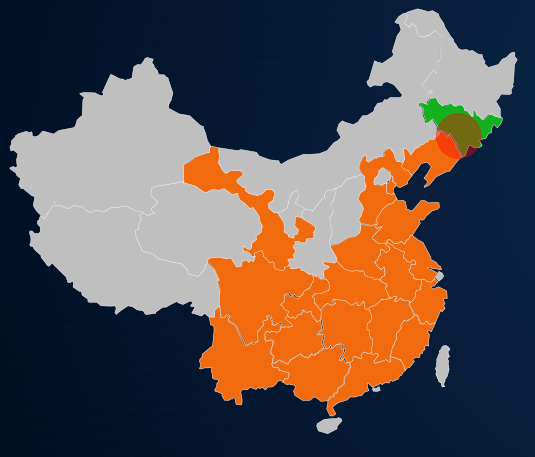
Currently, China's satellite remote sensing industry is ushering in a golden period of development driven by the triple resonance of policies, technologies, and markets. It has transitioned from the "technology accumulation" phase to "large-scale commercial application" and "value release", becoming an important part of the construction of national spatial information infrastructure.
It has been widely applied in various industries such as urban governance, ecological environmental protection, natural resources, agriculture, and forestry, serving as a core supporting force for digital transformation and refined management and control. Xinhe Hangyao Information Technology (Anhui) Co., Ltd. is deeply engaged in the field of satellite remote sensing. Based on its core capabilities of customized interpretation and regular monitoring, and closely focusing on the actual needs of customers in various industries, it integrates advanced satellite remote sensing technologies with industry application experience to create a comprehensive, full-process, and customized satellite remote sensing comprehensive service solution. This solution addresses industry pain points, activates data value, provides accurate, efficient, and convenient satellite remote sensing services for customers in various fields, and helps them achieve management upgrading and decision-making improvement.
I. Current Status of the Industry Market and Core Pain Points of Customers
(1) Current Status of the Industry Market
With the advancement of the country's "Space+" future industry layout and the intensive introduction of local special policies, the scale of the satellite remote sensing industry continues to expand. According to relevant data, the scale of China's satellite remote sensing industry reached 245 billion yuan in 2025, and the market scale of commercial remote sensing satellite data services exceeded 20 billion yuan. It is expected to reach 60 billion yuan by 2030, with a compound annual growth rate of over 25%. At present, the application of satellite remote sensing has been rapidly expanding from the traditional government affairs market to industries such as agriculture, forestry, new energy, and emergency management. The "space-sky-ground" integrated monitoring system has become a mainstream demand, but there are still obvious shortcomings in market services: most service providers focus on single-link services and lack full-process integration capabilities; data interpretation accuracy is insufficient and timeliness is lagging; solutions are seriously homogeneous and difficult to adapt to the needs of segmented industries; the technical threshold is high and the controllability of landing costs is poor. These issues have become core bottlenecks restricting the large-scale application of satellite remote sensing technology, and also provide a broad market space for professional enterprises with full-process service capabilities.
(2) Core Pain Points of Customers
Combining the seven major fields covered by the company's business, such as urban governance, ecological environmental protection, and natural resources, and considering the current market situation, the core pain points of customers are concentrated in 4 aspects, which are also the core issues that this solution focuses on solving:
1. Service fragmentation, with poor connection throughout the entire process
Most service providers in the current market can only offer services for a single link, such as only providing satellite image acquisition, or only providing basic data interpretation. They are unable to realize a full-process closed-loop service of "image acquisition - data processing - interpretation and analysis - monitoring and early warning - report output". Customers need to connect with multiple service providers, which not only increases communication costs and prolongs the service cycle, but also easily leads to problems such as inconsistent data standards and disconnected service connections. For example, in cultivated land monitoring, after customers obtain satellite images, they need to separately connect with interpretation institutions and then coordinate with control departments to implement disposal. The efficiency of the whole process is low, making it difficult to meet the needs of regular management and control.
2. Insufficient accuracy in interpretation, lag in timeliness, and weak decision support
The core value of satellite remote sensing services lies in "accuracy and timeliness". However, the industry currently faces two major issues: First, the accuracy of data interpretation is insufficient. Some service providers rely on generalized interpretation templates, lacking industry-specificity. The recognition accuracy for segmented scenarios (such as pine wood nematode disease, illegal straw burning, and the "non-grain use" of cultivated land) is low, with high rates of misjudgment and missed judgment, making it difficult to provide reliable data support. Second, there is a lag in timeliness. The traditional service process involves multiple links including "ground operation control—satellite imaging—ground station reception—data processing—interpretation and analysis". Customers often have to wait for several days or even weeks to obtain results, which cannot meet the high-frequency and rigid demand scenarios such as emergency management and illegal disposal. For example, in emergency scenarios like floods and forest fires, delayed monitoring data cannot support rapid decision-making. Meanwhile, the scarcity of high-quality remote sensing data and insufficient annotated data further affect the accuracy of interpretation and service quality.
3. Lack of customization, poor adaptability, and low utilization rate
The business needs of different industries and different customers vary significantly. However, most satellite remote sensing solutions on the market are seriously homogeneous, mostly being general-purpose templates, which cannot provide customized services based on customers' specific business processes and key management and control points. For example, agricultural customers need special interpretation services related to crop yield estimation and agricultural insurance claims, but general-purpose solutions can only provide basic agricultural situation images, which cannot meet their core needs; customers engaged in the creation of garden cities need special monitoring data such as vegetation coverage and greening growth, but most service providers are unable to offer targeted services. This leads to poor implementation and low utilization of the solutions, failing to give full play to the value of satellite remote sensing technology. In addition, traditional remote sensing services have a high threshold for use, requiring customers to have professional knowledge. Ordinary users find it difficult to directly utilize remote sensing data, which further reduces the service utilization rate.
4. Poor cost controllability, high technical threshold, and great difficulty in implementation
Satellite remote sensing technology integrates technologies from multiple fields such as satellite imaging, data processing, and interpretation and analysis, with a high technical threshold. Most customers (especially local government departments and small and medium-sized enterprises) lack their own professional technical teams and are unable to achieve data interpretation, service implementation, and later operation and maintenance. At the same time, the solutions of some service providers have problems of technical redundancy and over-development. In addition, the high costs of satellite image acquisition and data processing lead to high investment costs for customers, as well as high difficulty and cost in later operation and maintenance, making it difficult to achieve sustainable utilization. Furthermore, some service providers have non-transparent quotations and hidden consumption, which further increases the cost burden on customers.
II. Our Core Advantages (Xinhe Hangyao's Differentiated Competitive Edge)
Xinhe Hangyao has been rooted in the field of satellite remote sensing for many years, deeply cultivating application scenarios in various industries. Relying on the four core advantages of "full-process services, customization capabilities, precision technology, and low-cost implementation", it breaks through industry shortcomings and provides customers with more valuable comprehensive satellite remote sensing services. Compared with similar service providers in the market, our advantages are more in line with actual needs and more implementable:
(1) Full-process closed-loop service, which is worry-free and efficient, breaking the fragmentation of services
We are one of the few enterprises in the industry that can provide a full-process closed-loop service covering "satellite image acquisition, data processing, customized interpretation, regular monitoring, early warning push, report output, and technical support". Customers do not need to contact multiple service providers; instead, a dedicated person will follow up the entire process to solve all their satellite remote sensing-related needs in one stop. From investigating customer needs and accurately acquiring images, to data cleaning and professional interpretation, then to regular monitoring and abnormal warning, and finally to outputting detailed analysis reports and providing technical guidance, the entire process is seamlessly connected. This significantly shortens the service cycle, reduces customers' communication costs, and enables them to "save time, worry, and effort". Meanwhile, we integrate multi-source satellite resources to achieve regular coverage of images with high spatial, temporal, and spectral resolutions, which can meet the image acquisition needs of different customers.
(2) Customized interpretation + precise monitoring, meeting needs and enhancing decision-making value
1. Outstanding customization capability: We have deeply engaged in seven major fields such as urban governance, ecological environmental protection, and natural resources, and have a profound understanding of the business processes and control priorities of customers in various industries. We can customize exclusive interpretation standards, monitoring plans, and report templates according to customers' specific needs, rejecting generalized templates. For example, for agricultural insurance customers, we customize interpretation services for the affected area and degree of crops to provide accurate data for claims settlement; for mine supervision customers, we customize interpretation services for mine mining ranges and illegal mining sites to assist in compliance control; for emergency management customers, we optimize service processes to achieve rapid interpretation and result output within 1 hour in emergency scenarios, supporting rapid decision-making.
2. Double guarantee of accuracy and timeliness: Relying on a professional interpretation team (with rich experience in industry interpretation) and advanced intelligent interpretation technology, we integrate AI algorithms to optimize the interpretation process and improve interpretation accuracy. The misjudgment rate and missed judgment rate of interpretation for subdivided scenarios are controlled at an extremely low level; at the same time, we establish a normalized monitoring mechanism, combined with multi-source satellite image resources, to achieve daily, weekly, and monthly monitoring on demand, quickly obtain images, quickly process and interpret them, and promptly push monitoring results and abnormal warnings, completely solving the pain point of delayed timeliness in traditional services and providing reliable support for customers' accurate decision-making. In addition, we continuously accumulate industry interpretation data and improve the data annotation system to further enhance the accuracy and efficiency of interpretation.
(3) The technology is practical and controllable, with optimized costs, reducing the difficulty of implementation.
We abandon "technical redundancy" and focus on customers' core needs. We adopt a lightweight and modular technical architecture, optimize data processing procedures, integrate cost-effective satellite image resources, and significantly reduce service costs. Meanwhile, for customers of different scales and with different budgets, we provide hierarchical service solutions (Basic Edition, Advanced Edition, and Custom Edition), which can flexibly adapt to different needs such as "basic image acquisition + simple interpretation", "regular monitoring + precise interpretation + early warning push", and "full-process customization + technical operation and maintenance", ensuring that customers can realize the application of satellite remote sensing technology at a reasonable cost. In addition, we offer full-process technical support, providing customers with services such as data interpretation, operation training, and post-operation and maintenance, lowering the technical threshold for customers. Even if customers do not have a professional technical team, they can easily utilize satellite remote sensing services. At the same time, we adopt a combination of on-satellite intelligent preliminary screening and ground AI interpretation to reduce the transmission of invalid data and further lower service costs.
(4) Multi-field scenario accumulation, efficient service response, and reliable reputation
Our services cover multiple fields such as urban governance, ecological environmental protection, natural resources, water conservancy, agriculture, forestry, photovoltaic power stations, and high-voltage transmission. We have a wealth of industry application cases and practical experience, and have a deep understanding of the policy requirements and control difficulties in each field. We can respond quickly to customer needs and address their urgent demands (such as emergency monitoring and handling of violations). Achieve rapid connection and prompt implementation. Meanwhile, we have established a 7× 24-hour service response mechanism, equipped with professional service and technical teams to promptly solve the problems encountered by customers during use, conduct regular follow-up visits to customers, optimize service plans based on changes in customer business, ensure that services continuously meet customer needs, and have accumulated a good reputation in the industry.
Iii. Core Architecture and Service Content of the Solution
This solution takes "customer demands as the core, technology as the support, and value as the orientation", integrating advanced technologies such as satellite remote sensing, AI intelligent interpretation, and big data analysis. It builds an architecture system of "1 core service platform +7 specialized service scenarios + full-process supporting services", achieving "precise, efficient, customized, and regular" comprehensive satellite remote sensing services It comprehensively covers all business areas of the company and can be flexibly adjusted and customized for expansion according to customer needs.
(1) Core Service Platform: Satellite Remote Sensing Intelligent Service Platform
The platform serves as the core carrier of the solution, providing comprehensive functions such as interpretation and analysis, regular monitoring, early warning push, and report generation. It supports access from multiple terminals (computers and mobile devices), achieving full-process visualization and traceability of services. Core functions include: intelligent interpretation Integrating AI intelligent interpretation with manual review, it supports customized interpretation rules, accurately identifies monitoring objects in various industries (such as illegal land use, black and odorous water bodies, pine wood pests, straw burning, etc.), and automatically generates interpretation results and abnormal point location annotations.
Regular monitoring: Set the monitoring scope and indicators based on customer needs to achieve all-weather and regular monitoring. Automatically compare and analyze historical data, identify changing trends, and promptly push abnormal early warning information.
Report output: Supports customized report templates, automatically generates monitoring reports and interpretation reports, including data charts, anomaly analysis, handling suggestions, etc., which can be directly used in customer decision-making, filing and other scenarios.
Data Management: Establish a secure and efficient data management system to achieve centralized storage, query, and traceability of image data, interpretation results, monitoring reports, etc., ensuring data security.
(II) Seven specialized Service Scenarios (Adapted to the Company's Core Business)
Relying on the core service platform and in combination with the demands of various industries, we have created seven specialized satellite remote sensing service scenarios, providing targeted comprehensive services. We can customize and expand according to customer needs
1. Specialized services for urban governance
Focusing on the demands of urban refined governance, we provide regular satellite remote sensing monitoring and customized resolution services, covering urban public facility monitoring, identification of illegal construction, urban environmental monitoring and other contents. We accurately identify abnormal points in urban governance (such as illegal construction, street vending, environmental pollution, etc.), push early warning information and output governance suggestions. Help enhance the refinement and intelligence of urban governance, and provide data support for urban planning and control decision-making.
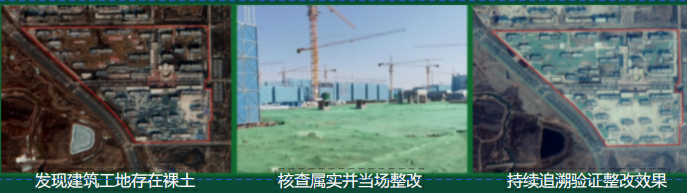
Remote sensing monitoring of urban governance
2. Specialized services for ecological and environmental protection
In response to the core demands of the ecological and environmental protection field, we provide comprehensive satellite remote sensing services, including: remote sensing monitoring of black and odorous water bodies (identifying the scope and pollution level of black and odorous water bodies, and tracking the effectiveness of governance); Monitoring of the "Four Disorders" in rivers and lakes (accurately identifying violations such as random occupation, random mining, random piling, and random construction, and achieving regular control); Monitoring of Straw removal from fields and illegal burning (Real-time monitoring of hotspots of straw burning, tracking the progress of straw removal from fields, and assisting in air pollution prevention and control) Monitoring for the creation of garden cities (monitoring the coverage of urban vegetation and the growth of greenery, assessing the effectiveness of greening, and providing data support for the creation of garden cities) helps clients precisely carry out ecological governance and consolidate the governance achievements.
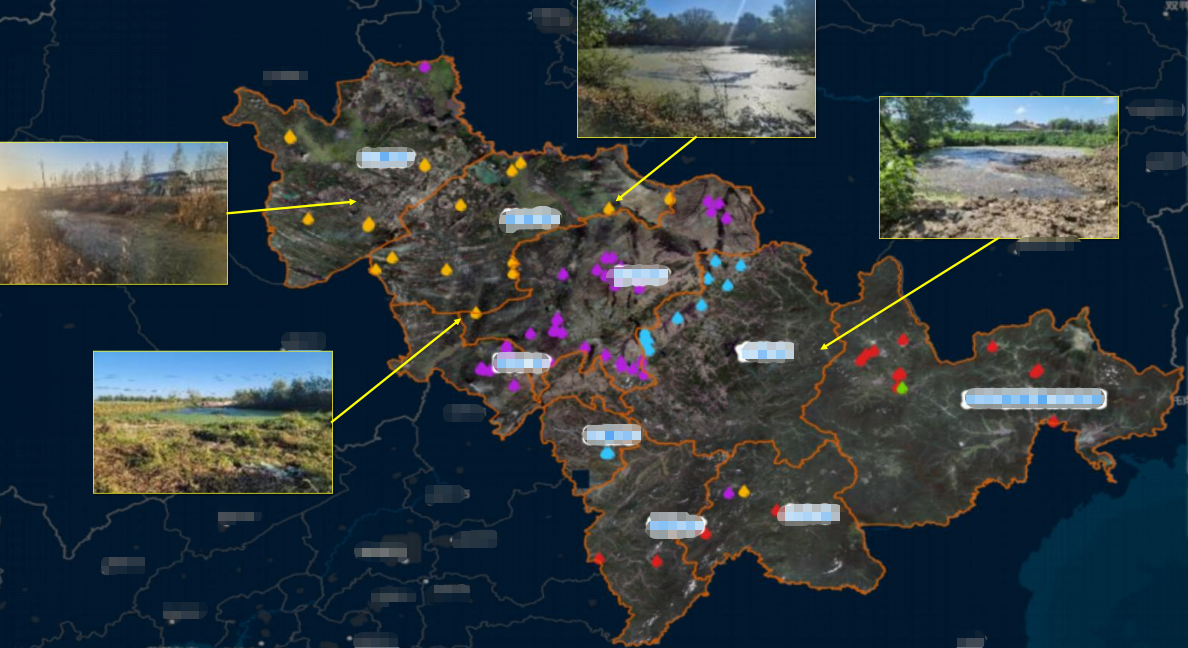
Remote sensing monitoring of black and odorous water bodies
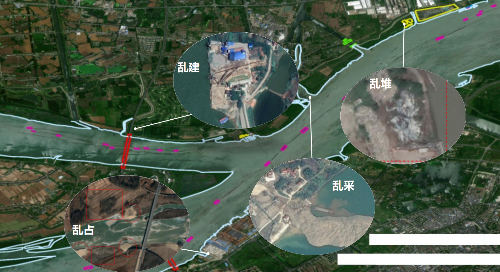
Remote sensing monitoring of the four disorders in rivers and lakes
3. Specialized services for natural resources
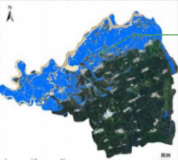
Closely adhering to the requirements of natural resource control, we provide professional satellite remote sensing services, covering the monitoring of "non-agriculturalization" and "non-grain-ization" of cultivated land (accurately identifying changes in cultivated land use and adhering to the red line of cultivated land). Mine resource supervision (monitoring the mining scope and progress of mines, identifying issues such as illegal mining and inadequate mine restoration); Monitoring of illegal land use and construction (Real-time monitoring of illegal land use and non-compliant construction, timely push of early warnings, and assistance in rapid response); Land use monitoring (analyzing changes in land use types to provide decision support for land planning and optimal resource allocation), and building a three-dimensional supervision system of "aerial inspection + ground verification + platform analysis and judgment". For instance, drawing on the core experience of Xiangyang's "Sky Eye +AI" smart model for farmland protection, we provided regular monitoring services for farmland to the local natural resources department. We integrated multi-source satellite image resources and built a dedicated AI recognition model to automatically identify and quickly warn of issues such as farmland occupation and illegal construction, helping the local area to safeguard the red line of farmland. It has significantly reduced the proportion of newly added illegal construction land. Its service model is replicable and scalable, and has been highly recognized by customers.
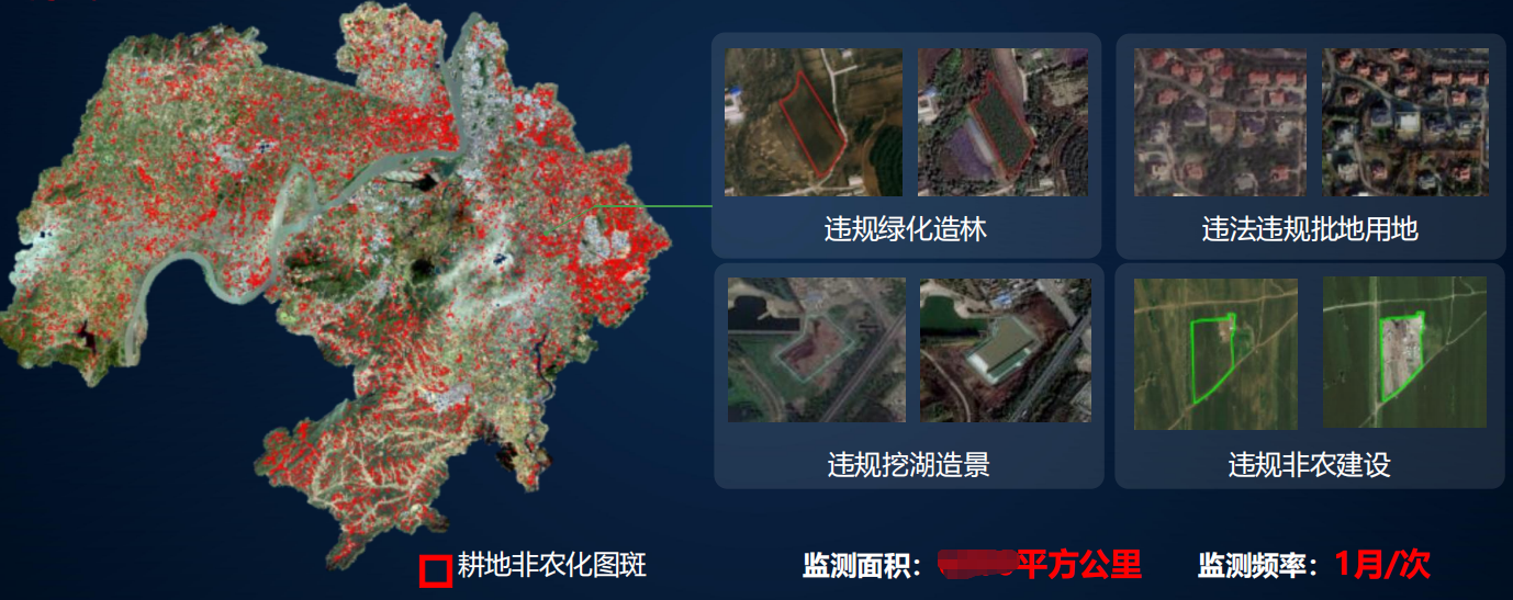
Remote sensing monitoring of "non-agriculturalization" and "non-grainization" of cultivated land
4. Specialized services for water affairs and water conservancy
To meet the management and control requirements in the water affairs and water conservancy field, we provide comprehensive satellite remote sensing monitoring services, covering water resource distribution monitoring, water conservancy project construction monitoring, water condition change monitoring, soil erosion monitoring, etc. We accurately grasp the dynamics of water resources, the progress of water conservancy projects and the water ecological status, and push abnormal warnings (such as abnormal water levels, aggravated soil erosion, etc.) Provide data support for water affairs and water conservancy planning, water resources management, and prevention of floods and droughts.
Remote sensing monitoring of water conditions
5. Specialized agricultural services
Focusing on the demands of high-quality agricultural development, we provide customized satellite remote sensing services, including: monitoring of high-standard farmland construction (tracking the progress and quality of high-standard farmland construction to ensure compliance with standards); Remote sensing monitoring of agricultural conditions (monitoring the growth of crops, planting distribution, and identifying diseases, pests, droughts, floods and other disasters); Crop area monitoring and yield estimation (precise statistics of crop planting area, scientific estimation of yield, providing support for agricultural production scheduling); Specialized agricultural insurance services (accurately identifying the extent and severity of crop damage, providing objective and precise data basis for agricultural insurance claims) facilitate the large-scale and precise development of agriculture. For instance, we provide remote sensing monitoring services for agricultural conditions to the local agricultural department and large-scale grain producers. We use 0.5-meter high-resolution satellite images to scan farmlands regularly every month and combine AI algorithms to create "digital portraits" of crops such as rice and wheat. We monitor the growth of crops in real time and promptly send out disease and pest warnings to assist large-scale grain producers in carrying out unified prevention and control. At the same time, by integrating meteorological data to generate yield prediction models, it helps optimize agronomy and increase the per-unit yield of crops by 5% to 10%, effectively leveraging the supporting role of satellite remote sensing technology in agricultural production.
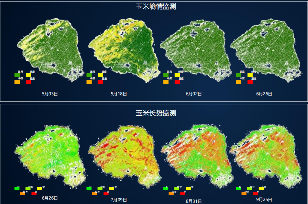
Remote sensing monitoring of agricultural soil moisture
6. Specialized forestry services
In response to the demands for the protection and management of forestry resources, we provide comprehensive satellite remote sensing services, including: remote sensing monitoring of changes in forest, grassland and wetland resources (monitoring the area and coverage changes of forest land, grassland and wetland to assist in resource protection); Forestry resources census and statistics (precise census of the distribution and reserves of forestry resources to provide data support for forestry resources management); Monitoring of pine wood pests (early identification of the distribution and spread trend of pine wood pests, push early warning information, assist in timely prevention and control, and reduce resource loss), and improve the efficiency and protection level of forestry resource management.
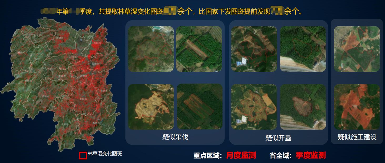
Remote sensing monitoring of changes in forest, grassland and wetland resources
Remote sensing monitoring of forest diseases and epidemics
7. Specialized services for other industries
Adapt to the demands of other industries such as photovoltaic power stations, high-voltage transmission lines, engineering projects, and emergency management, and provide targeted satellite remote sensing services: photovoltaic power station monitoring (monitoring the layout of photovoltaic power stations, the operating status of components, identifying issues such as vegetation occlusion and equipment failures); Remote sensing monitoring of high-voltage transmission lines (monitoring potential hazards around transmission lines and the integrity of lines to facilitate safe operation and maintenance of lines); Remote sensing supervision of engineering projects (monitoring the construction progress of engineering projects, construction compliance, and identifying illegal construction behaviors); Emergency management monitoring (for emergency scenarios such as floods, forest fires, and geological disasters, quickly obtain satellite images, interpret the scope and losses of the disaster, and provide decision support for emergency response and post-disaster reconstruction).
Remote sensing monitoring of photovoltaic power stations
(3) Full-process supporting services
To ensure the effective implementation of our services, we offer a full-process supporting service, integrating the entire chain from "demand - implementation - operation and maintenance", so that customers have no worries: Demand research: Dedicated personnel connect with customers to deeply understand their business processes, key control areas, and budget ranges, clarify service demands, and form a demand research report. Customized solution: Based on the results of the demand research, a dedicated satellite remote sensing comprehensive service plan is customized, clearly defining the service content, service cycle, charging standards, technical standards, etc., and submitted to the client for review and confirmation. Service implementation: A professional team is responsible for the entire process of services including image acquisition, data processing, interpretation and analysis, monitoring and early warning, etc. They follow up on the service progress throughout the process and provide timely feedback on the service results. Technical training: Provide customers with technical training on platform operation, data interpretation, application of results, etc., to ensure that the customer's management personnel can skillfully use the service platform and utilize the service results. Operation and maintenance optimization: Provide long-term operation and maintenance services, regularly update platform functions, optimize interpretation rules, and promptly solve problems encountered by customers during usage. Adjust the service plan in accordance with the changes in the customer's business to ensure that the service continuously meets the customer's needs. Data security assurance: Establish a strict data security management system, encrypt and store core materials such as customers' image data, interpretation results, and business information, strictly keep them confidential, prevent information leakage, and protect customers' rights and interests.
Iv. Core Value of the Solution
This solution is based on the actual needs of customers, breaks through the shortcomings of the industry, and creates four core values for customers, helping them achieve digital and refined control upgrades
(1) Reduce costs and increase efficiency to enhance management and control efficiency
Full-process closed-loop service reduces customer connection costs and communication costs, and shortens the service cycle. Regular monitoring replaces some manual inspections, alleviates the pressure on grassroots inspections, and reduces labor costs. Intelligent interpretation enhances work efficiency, reduces manual intervention, and enables customers to focus more energy on core control tasks, achieving "time-saving, labor-saving, and cost-saving". Meanwhile, the application of AI technology has significantly enhanced the efficiency of interpretation, saving over 70% of labor costs and further reducing the management and control costs for customers.
(2) Precise empowerment and optimization of decision-making quality
Customized interpretation and precise monitoring ensure the accuracy and pertinence of data results, avoiding misjudgment and missed judgment. Real-time push of abnormal warnings and analysis of changing trends provide customers with comprehensive, timely and reliable data support, avoiding blind decision-making, helping customers formulate scientific and reasonable control and governance plans, and improving the quality of decision-making and control effects. At the same time, transform abstract satellite images into intuitive analysis results, lower the usage threshold, and enable ordinary users to also utilize remote sensing data to assist in decision-making.
(3) Adapt to demands and unleash technological value
Abandon homogeneous templates, provide customized service plans, precisely adapt to the core demands of various industries and customers, and ensure strong service implementation and high utilization rate. It comprehensively covers seven major industry scenarios and can be flexibly expanded, enabling satellite remote sensing technology to truly integrate into customers' business processes, fully leverage its technological value, and assist customers in achieving digital transformation.
(4) Long-term adaptation to achieve continuous value
The lightweight and modular architecture can flexibly adapt to changes in customers' business and upgraded demands. Long-term operation and maintenance services and solution optimization ensure that the services continuously meet the development needs of customers. The hierarchical service plan can gradually upgrade services based on the customer's budget and demands, ensuring that every penny invested by the customer can achieve long-term returns and helping the customer build a sustainable and refined management system. At the same time, relying on policy dividends, we help customers seize the opportunities of digital transformation and enhance their core competitiveness.
V. Applicable Customers and Cooperation Models
(1) Applicable customers
This solution is widely applicable to all fields covered by the company's business. Core customers include: government departments: urban management, ecological environment, natural resources, water conservancy, agriculture and rural areas, forestry, emergency management, housing and urban-rural development and other relevant departments, used for industry control, decision support, filing and assessment, etc. Enterprises and institutions: photovoltaic power station operation enterprises, power transmission enterprises, engineering project construction enterprises, agricultural planting enterprises, forestry management enterprises, agricultural insurance companies, etc., for production operation and maintenance, risk control, cost optimization, etc. Other relevant units: research institutions, surveying and mapping units, planning and design units, etc., for scientific research, project design, data support, etc.
(II) Cooperation Mode
Based on customer demands and budgets, we offer flexible and diverse cooperation models, with the core including three types that can be customized as needed: Customized service model: According to the specific needs of customers, we customize exclusive satellite remote sensing comprehensive service plans, clearly define service contents and service cycles, charge service fees in one lump sum or in installments, and provide full-process services and technical support throughout the process. Regular annual package service model: For customers with long-term monitoring needs, we offer an annual package service, charging service fees on an annual basis. We provide regular services such as image acquisition, interpretation and analysis, early warning push, and report output as needed, which is more cost-effective. Module splitting service model: For customers who only need a single service link, the service module can be split (such as only image acquisition, only customized interpretation, only platform usage, etc.), and the corresponding module service fee can be charged separately to flexibly adapt to the personalized needs of customers.
Vi. Company Commitments and Service Guarantees
Xinhe Hangyao has always adhered to the service philosophy of "customer first, precision and efficiency, pragmatism and innovation, integrity and win-win". With professional technology, rich experience and efficient service, it provides customers with high-quality satellite remote sensing comprehensive services. It solemnly promises: Precise guarantee Strictly control the quality of service. The accuracy of interpretation and the timeliness of images should meet the standards agreed upon by customers, and eliminate problems such as misjudgment, missed judgment and service delay. Efficient response: 7× 24-hour service response, quickly connecting and promptly resolving customer demands and issues, and ensuring rapid implementation of urgent needs. Cost transparency: Quotations are open and transparent, eliminating hidden consumption. Service content and charging standards are clearly defined to ensure that customer costs are controllable. Customized adaptation: Deeply understand the customer's needs to ensure that the service plan is highly consistent with the customer's business, and can be used immediately upon implementation with immediate results. Data confidentiality: Strictly keep all core customer information confidential, establish a complete data security guarantee system, prevent information leakage, and safeguard the legitimate rights and interests of customers. Long-term support: Provide long-term operation and maintenance services and solution optimization. Adjust the service content in a timely manner according to the changes in the customer's business to ensure that the service continuously meets the customer's needs.