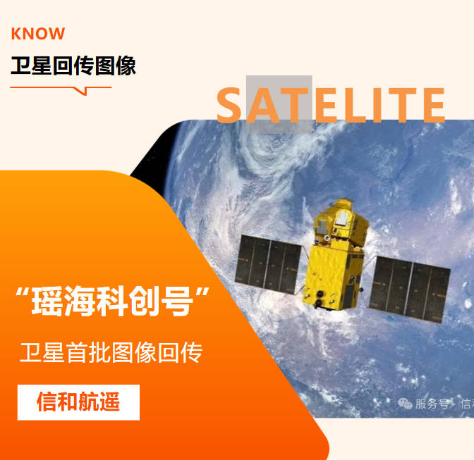
As satellites precisely capture surface changes in the vast expanse of the sky, and drones soar like agile birds over mountains, rivers, lakes, and seas, while ground sensor networks transmit real-time data pulses... a brand-new monitoring paradigm is reshaping our traditional management approaches. This is “integrated sky-ground monitoring technology.”
What is 'Sky-Ground Integrated' Monitoring
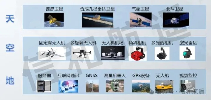
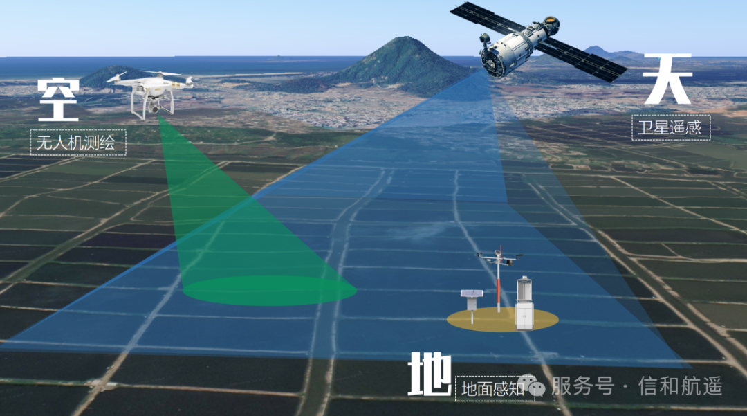
“Sky-Ground Integrated” monitoring is a comprehensive approach that leverages three key methods—space-based (remote sensing satellites), air-based (drones and manned aircraft), and ground-based (ground sensors and IoT devices)—to build a three-dimensional monitoring network that is all-encompassing, available around the clock, and highly accurate.
Like a 'thousand-mile eye' deployed in space, it boasts wide coverage and strong periodicity, enabling the acquisition of large-scale, long-term, high-resolution imagery data to grasp the overall regional situation.
Flexible and agile, capable of rapid response, allowing for high-resolution, high-frequency, detailed inspections of key areas and filling in the “blind spots” of satellites.
Deploy various sensors and IoT devices, combined with internet communication, digital twins, and other technologies, to provide the most authentic and precise “first-hand” data and enable visualized management and presentation.
The three parties collaborate synergistically, complementing each other’s strengths to form a complete closed loop—“macro-level control, meso-level detailed investigation, and micro-level visualization”—truly achieving “comprehensive visibility, accurate investigation, and effective management.”
Why do we need “sky-ground integration”?
Traditional monitoring methods rely on manual inspections and fixed-point observations, which suffer from issues such as incomplete coverage, low efficiency, delayed response, and data silos. Faced with increasingly complex management demands, we urgently need stronger technological support:
Responding to sudden environmental incidents
Algal blooms, forest fires, illegal wastewater discharge... these issues demand rapid detection, precise localization, and dynamic tracking.
Protecting natural resources
Cracking down on activities such as damaging farmland, illegal land use, unauthorized construction, illegal sand and gravel mining, destruction of forest land, and encroachment on wetlands requires continuous, covert, and highly efficient monitoring methods.
Supporting scientific decision-making
Ecological conservation supervision, land space planning, carbon sink monitoring and assessment, and refined urban management all require massive, precise, and multi-dimensional data support.
Enhance Management Efficiency
Say goodbye to 'mass manpower tactics,' leverage data-driven management, and achieve a shift from 'passive response' to 'proactive prevention.'
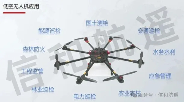
Our technology empowers smart governance across multiple fields
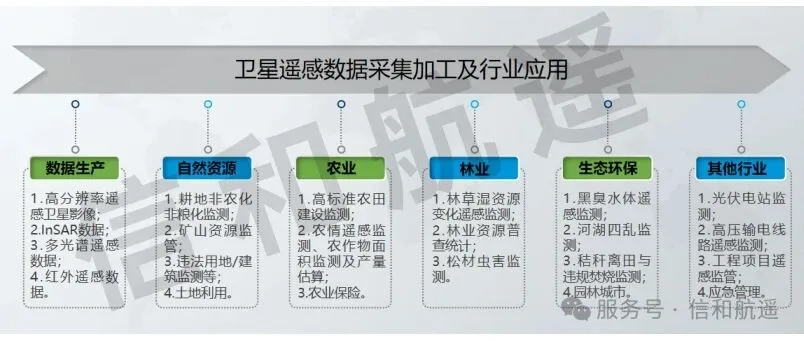
Natural Resource Management
From ‘Passive Detection’ to ‘Proactive Supervision’
Smart Identification of Illegal Land Use: Regular satellite scans + targeted drone inspections automatically detect illegal constructions and non-compliant developments, enabling “early detection and early intervention.”
Dynamic Monitoring of Mineral Resources: Monitor the scope of mining operations, changes in stockpiles, and progress in ecological restoration, and crack down on illegal mining activities.
Farmland and Forest Land Protection:Real-time monitoring of farmland ‘non-agriculturalization’ and ‘non-grainization,’ as well as deforestation in forest lands, to safeguard the ecological redlines.
Support for Territorial Spatial Planning:Providing high-precision data on land cover, topography, land use, and other foundational information to support scientific planning.
Ecological and Environmental Protection
Leave no room for pollution to hide
Water Environment Monitoring: Satellites identify cyanobacterial blooms and thermal anomalies at discharge outlets; drones patrol rivers to detect wastewater discharge and black-and-odorous water bodies; ground-based sensors monitor water quality parameters in real time, enabling a three-dimensional “water-land-air” monitoring system.
Ecosystem Protection Red Line Monitoring: Dynamically monitor human activity interference in sensitive areas such as nature reserves and wetland parks, and protect biodiversity.
Identification of Illegal Solid Waste Disposal: Utilizing remote sensing image change detection to quickly identify illegal dumping sites.
Water Resources and Water Management
Smart Water Protection, Scientific Flood Control
Rectification of the 'Four Disruptions' in Rivers and Lakes: Automatically identifies issues such as illegal occupation, illegal mining, illegal dumping, and illegal construction within river channels, enhancing the efficiency of the river chief system management.
Safety Monitoring of Water Conservancy Projects: Conducts deformation monitoring of dams, embankments, and reservoirs to promptly detect potential safety hazards.
Flood Disaster Warning and Assessment:Identify flood-prone areas before heavy rainfall, monitor the extent of flooding in real time during a disaster, and rapidly assess damage afterward to support emergency decision-making.
Water Resource Management:Monitor changes in reservoir and lake water levels, assess water resource availability, and support water resource allocation.
Agricultural and Rural Regulation
Supports the entire process of selecting sites for high-standard farmland, comprehensive monitoring of construction progress, remote sensing-based agricultural condition monitoring, crop area monitoring and yield estimation, verification of agricultural insurance claims, and improvement of rural living environments.
Urban Governance
Smart AI inspection by drones in fields such as urban governance, transportation and highways, water resources and hydraulics, energy and chemical industries, forest fire prevention, construction engineering, and mining production.
Various Resource Surveys and Change Management
It can also be applied to a wide range of industries, including various resource surveys and change monitoring, remote sensing-based monitoring of safety hazards along high-voltage transmission line corridors, project management and statistical analysis, claims assistance in the insurance industry, monitoring of straw removal from fields and illegal burning, emergency management, and many others.
Advantage: More than just “seeing”—it’s about “intelligence”
We don’t just provide data
we also offer intelligent decision-support services
AI-powered intelligent interpretation: Utilizing deep learning algorithms to automatically identify changes in land features, illegal activities, and pollution patterns, significantly boosting analysis efficiency.
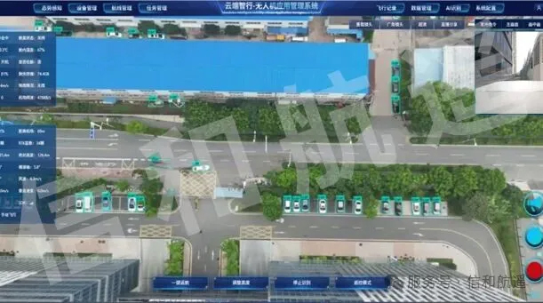
Big data integration platform: Integrating multi-source data to build a unified spatiotemporal database, enabling visualized management through a single “map”.
Early Warning and Forecasting Model:Build predictive models based on historical data and real-time monitoring.
Customized Reporting Services:Provide monthly, quarterly, and annual monitoring reports to support management, performance evaluation, law enforcement, and planning.
Conclusion
Let the light of technology illuminate the path toefficient regulation
“Sky-Ground-Integrated” is not just a technological innovation; it’s also an upgrade in governance philosophy. It empowers us to perceive, understand, and safeguard our Earth home—our very lifeline—with unprecedented breadth, depth, and precision.
In the future, we will continue to delve deeply into cutting-edge technologies such as remote sensing, AI, and IoT, constantly optimizing monitoring models and service approaches to provide smarter, more efficient, and more reliable technological support for fields including natural resources, ecological conservation, water resources management, infrastructure construction, and refined urban management.
Protecting our green mountains and clear waters—we’re always on the road.
If you have needs for sky-ground-integrated monitoring or would like to learn more about technical details, please scan the code to follow our official account or call us for consultation. We warmly invite you to visit our company in person and receive tailored solutions.